Vaires-sur-Marne night lights from space
Night Light of Vaires-sur-Marne (Île-de-France) from space (France) Src. Average luminocity for 10x10km area is 80.4759% and for 50x50km: 53.2414%.
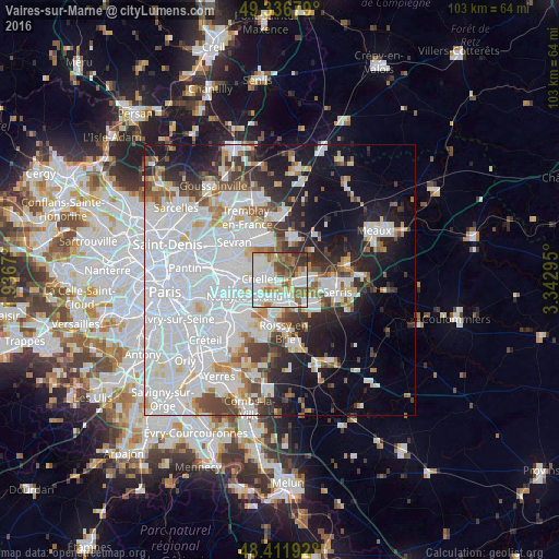
Analysis of Vaires-sur-Marne night lights 2016
Square area 10x10 km:
 24.86%
90-99
27.56%80-89
7.95%70-79
6.39%60-69
9.94%50-59
11.79%40-49
5.26%30-39
5.54%20-29
0.71%10-19
0%0-9
0%Square area 50x50 km:
25.1%90-99
11.8%80-89
3.29%70-79
2.92%60-69
3.74%50-59
3.59%40-49
4.01%30-39
4.21%20-29
6.45%10-19
12.42%0-9
22.46%Clear (daylight) street map image can be seen on geolist.org.
Map coordinates:
49° 20' 12.4" North, 1° 56' 12.1" East
48° 52' 35.4" North, 2° 38' 23.4" East
48° 24' 42.9" North, 3° 20' 34.6" East
Some cities around Vaires-sur-Marne sort by population:
• Chelles
3.5 km =2.2 mi,  278°
278°
• Champs-sur-Marne
4.1 km =2.5 mi,  224°
224°
• Torcy
3 km =1.9 mi,  164°
164°
• Montfermeil
5.1 km =3.2 mi,  298°
298°
• Lognes
4.6 km =2.9 mi,  188°
188°
• Noisiel
3.3 km =2.1 mi,  200°
200°
• Saint-Thibault-des-Vignes
3 km =1.9 mi,  101°
101°
• Gournay-sur-Marne
4.3 km =2.7 mi,  248°
248°
2971157 (p: 12,547)
Sources (retrieved 2019-11-25):
» Earth at Night: Flat Maps 2012, 2016