Bois-Guillaume night lights from space
Night Light of Bois-Guillaume (Normandy) from space (France) Src. Average luminocity for 10x10km area is 64.2591% and for 50x50km: 15.2615%.
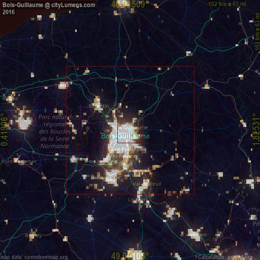
Analysis of Bois-Guillaume night lights 2016
Square area 10x10 km:
 27.17%
90-99
17.79%80-89
2.94%70-79
2.24%60-69
4.76%50-59
5.74%40-49
3.08%30-39
9.1%20-29
12.61%10-19
11.2%0-9
3.36%Square area 50x50 km:
3.52%90-99
2.91%80-89
0.94%70-79
1.36%60-69
1.49%50-59
1.8%40-49
2.2%30-39
2.77%20-29
4.48%10-19
8.2%0-9
70.33%Clear (daylight) street map image can be seen on geolist.org.
Map coordinates:
49° 54' 54.3" North, 0° 25' 8.6" East
49° 27' 36.7" North, 1° 7' 19.9" East
49° 0' 3.8" North, 1° 49' 31.1" East
Some cities around Bois-Guillaume sort by population:
• Rouen
2.5 km =1.6 mi,  221°
221°
• Sotteville-lès-Rouen
6.1 km =3.8 mi,  202°
202°
• Mont-Saint-Aignan
2.1 km =1.3 mi,  278°
278°
• Déville-lès-Rouen
5.2 km =3.2 mi, 281°
• Darnétal
2.7 km =1.7 mi,  128°
128°
• Bihorel
0.6 km =0.4 mi,  179°
179°
• Notre-Dame-de-Bondeville
5.8 km =3.6 mi,  296°
296°
• Le Mesnil-Esnard
5.5 km =3.4 mi,  162°
162°
3032025 (p: 13,711)
Sources (retrieved 2019-11-25):
» Earth at Night: Flat Maps 2012, 2016