Santa Comba night lights from space
Night Light of Santa Comba (Galicia) from space (Spain) Src. Average luminocity for 10x10km area is 4.3587% and for 50x50km: 7.0545%.
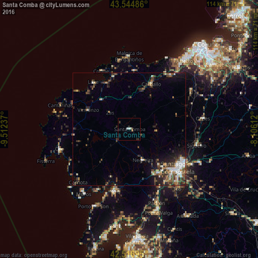
Analysis of Santa Comba night lights 2016
Square area 10x10 km:
 0.95%
0.95%90-99
0.95%80-89
0%70-79
0.63%60-69
0%50-59
0%40-49
0.63%30-39
0.95%20-29
2.22%10-19
0.16%0-9
93.49%Square area 50x50 km:
0.81%90-99
1.17%80-89
0.55%70-79
0.47%60-69
0.74%50-59
1.25%40-49
1.52%30-39
1.59%20-29
2.62%10-19
3.07%0-9
86.21%Clear (daylight) street map image can be seen on geolist.org.
Map coordinates:
43° 32' 41.5" North, 9° 30' 44.5" West
43° 1' 59" North, 8° 48' 33.3" West
42° 31' 1" North, 8° 6' 22" West
Some cities around Santa Comba sort by population:
• Santiago de Compostela
27.3 km =17 mi,  128°
128°
• Carballo
22.2 km =13.8 mi,  25°
25°
• Amés
19 km =11.8 mi,  138°
138°
• Laracha
30.5 km =19 mi,  36°
36°
• Outes
20.5 km =12.7 mi,  201°
201°
• Coristanco
19.2 km =11.9 mi,  14°
14°
• Negreira
15.3 km =9.5 mi,  159°
159°
• Mazaricos
16.8 km =10.4 mi,  232°
232°
3109966 (p: 10,487)
Sources (retrieved 2019-11-25):
» Earth at Night: Flat Maps 2012, 2016