Outes night lights from space
Night Light of Outes (Galicia) from space (Spain) Src. Average luminocity for 10x10km area is 3.5492% and for 50x50km: 8.5092%.
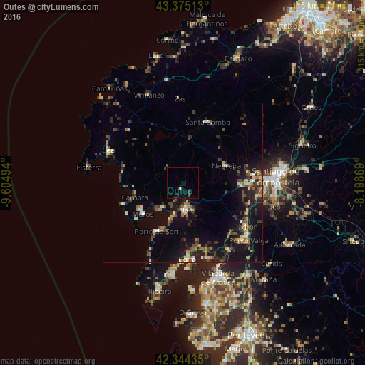
Analysis of Outes night lights 2016
Square area 10x10 km:
 0%
0%90-99
0.63%80-89
0%70-79
0%60-69
0%50-59
0.48%40-49
1.11%30-39
0.16%20-29
2.06%10-19
1.27%0-9
94.29%Square area 50x50 km:
0.28%90-99
1.24%80-89
0.73%70-79
0.86%60-69
1.07%50-59
1.22%40-49
1.58%30-39
1.77%20-29
2.94%10-19
8.46%0-9
79.84%Clear (daylight) street map image can be seen on geolist.org.
Map coordinates:
43° 22' 30.5" North, 9° 36' 17.8" West
42° 51' 42.8" North, 8° 54' 6.5" West
42° 20' 39.7" North, 8° 11' 55.3" West
Some cities around Outes sort by population:
• Amés
20.6 km =12.8 mi,  76°
76°
• Boiro
23.9 km =14.9 mi,  176°
176°
• Santa Comba
20.5 km =12.7 mi,  21°
21°
• Muros
16.1 km =10 mi,  233°
233°
• Porto do Son
17.4 km =10.8 mi,  208°
208°
• Negreira
13.8 km =8.6 mi,  70°
70°
• Mazaricos
10.4 km =6.5 mi,  326°
326°
• Carnota
15.9 km =9.9 mi,  254°
254°
3114726 (p: 7,902)
Sources (retrieved 2019-11-25):
» Earth at Night: Flat Maps 2012, 2016