Negreira night lights from space
Night Light of Negreira (Galicia) from space (Spain) Src. Average luminocity for 10x10km area is 6.046% and for 50x50km: 10.3975%.
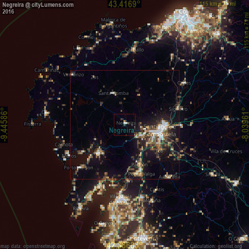
Analysis of Negreira night lights 2016
Square area 10x10 km:
 0.48%
0.48%90-99
1.11%80-89
0.32%70-79
0.32%60-69
0.32%50-59
0.32%40-49
1.27%30-39
1.27%20-29
2.86%10-19
2.38%0-9
89.37%Square area 50x50 km:
0.94%90-99
1.57%80-89
0.6%70-79
0.9%60-69
1.39%50-59
1.72%40-49
2.03%30-39
2.28%20-29
3.5%10-19
8.93%0-9
76.14%Clear (daylight) street map image can be seen on geolist.org.
Map coordinates:
43° 25' 0.8" North, 9° 26' 45.1" West
42° 54' 14.5" North, 8° 44' 33.8" West
42° 23' 12.6" North, 8° 2' 22.6" West
Some cities around Negreira sort by population:
• Santiago de Compostela
16.3 km =10.1 mi,  99°
99°
• Amés
7.1 km =4.4 mi,  89°
89°
• Santa Comba
15.3 km =9.5 mi,  339°
339°
• Padrón
19.6 km =12.2 mi,  159°
159°
• Outes
13.8 km =8.6 mi,  250°
250°
• Valga
24.4 km =15.2 mi, 159°
• Mazaricos
19.1 km =11.9 mi,  282°
282°
• Vedra
25.8 km =16 mi,  122°
122°
3115523 (p: 7,079)
Sources (retrieved 2019-11-25):
» Earth at Night: Flat Maps 2012, 2016