Padrón night lights from space
Night Light of Padrón (Galicia) from space (Spain) Src. Average luminocity for 10x10km area is 26.3545% and for 50x50km: 18.1662%.
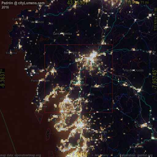
Analysis of Padrón night lights 2016
Square area 10x10 km:
100  0.61%
0.61%
90-99 3.94%
80-89 3.64%
70-79 4.39%
60-69 1.52%
50-59 6.21%
40-49 4.09%
30-39 4.09%
20-29 6.82%
10-19 39.09%
0-9 25.61%
0.61%90-99
3.94%80-89
3.64%70-79
4.39%60-69
1.52%50-59
6.21%40-49
4.09%30-39
4.09%20-29
6.82%10-19
39.09%0-9
25.61%Square area 50x50 km:
100 1.43%
90-99 2.94%
80-89 1.71%
70-79 2.01%
60-69 2.92%
50-59 2.82%
40-49 2.98%
30-39 3.11%
20-29 6.64%
10-19 16.3%
0-9 57.14%
1.43%90-99
2.94%80-89
1.71%70-79
2.01%60-69
2.92%50-59
2.82%40-49
2.98%30-39
3.11%20-29
6.64%10-19
16.3%0-9
57.14%Clear (daylight) street map image can be seen on geolist.org.
Map coordinates:
43° 15' 10.8" North, 9° 21' 49.3" West
42° 44' 19.5" North, 8° 39' 38.1" West
42° 13' 12.7" North, 7° 57' 26.8" West
Some cities around Padrón sort by population:
• Ribeira
17.7 km =11 mi,  87°
87°
• A Estrada
15.1 km =9.4 mi,  111°
111°
• Teo
13.2 km =8.2 mi,  84°
84°
• Rianxo
16.2 km =10.1 mi,  232°
232°
• Caldas de Reis
15 km =9.3 mi,  174°
174°
• Valga
4.9 km =3 mi,  159°
159°
• Cuntis
14.1 km =8.8 mi,  145°
145°
• Vedra
15.7 km =9.8 mi,  73°
73°
3114643 (p: 9,039)
Sources (retrieved 2019-11-25):
» Earth at Night: Flat Maps 2012, 2016