Astorga night lights from space
Night Light of Astorga (Castille and León) from space (Spain) Src. Average luminocity for 10x10km area is 18.581% and for 50x50km: 4.4025%.
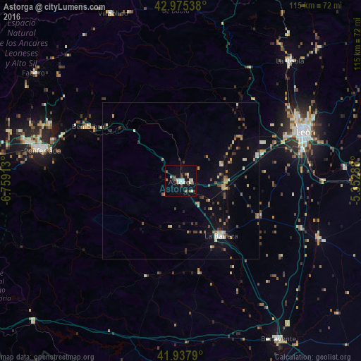
Analysis of Astorga night lights 2016
Square area 10x10 km:
 1.9%
1.9%90-99
5.24%80-89
1.11%70-79
0.32%60-69
2.06%50-59
3.49%40-49
3.02%30-39
2.22%20-29
1.27%10-19
11.27%0-9
68.1%Square area 50x50 km:
0.21%90-99
0.82%80-89
0.4%70-79
0.54%60-69
0.42%50-59
0.61%40-49
0.52%30-39
0.67%20-29
0.87%10-19
2.04%0-9
92.9%Clear (daylight) street map image can be seen on geolist.org.
Map coordinates:
42° 58' 31.4" North, 6° 45' 32.9" West
42° 27' 31.6" North, 6° 3' 21.6" West
41° 56' 16.4" North, 5° 21' 10.4" West
Some cities around Astorga sort by population:
• León
42.8 km =26.6 mi,  68°
68°
• Ponferrada
45.3 km =28.1 mi,  282°
282°
• San Andrés del Rabanedo
39.8 km =24.7 mi,  64°
64°
• Villaquilambre
45.8 km =28.5 mi, 62°
• La Bañeza
21.9 km =13.6 mi,  143°
143°
• Villablino
57.6 km =35.8 mi,  338°
338°
• Bembibre
34.3 km =21.3 mi,  300°
300°
• Cacabelos
56.9 km =35.4 mi,  286°
286°
3129231 (p: 12,078)
Sources (retrieved 2019-11-25):
» Earth at Night: Flat Maps 2012, 2016