Cacabelos night lights from space
Night Light of Cacabelos (Castille and León) from space (Spain) Src. Average luminocity for 10x10km area is 20.8167% and for 50x50km: 5.9367%.
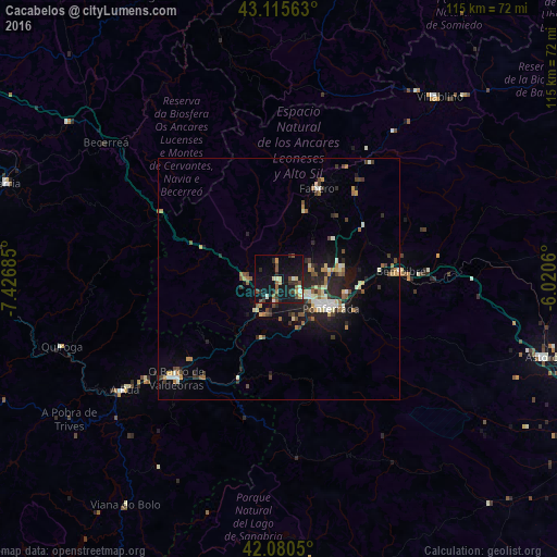
Analysis of Cacabelos night lights 2016
Square area 10x10 km:
 0.3%
0.3%90-99
3.48%80-89
2.88%70-79
1.82%60-69
1.67%50-59
4.7%40-49
2.88%30-39
3.18%20-29
6.67%10-19
28.18%0-9
44.24%Square area 50x50 km:
0.37%90-99
0.89%80-89
0.84%70-79
0.64%60-69
0.78%50-59
0.79%40-49
0.96%30-39
0.88%20-29
1.97%10-19
4.19%0-9
87.7%Clear (daylight) street map image can be seen on geolist.org.
Map coordinates:
43° 6' 56.3" North, 7° 25' 36.7" West
42° 36' 0.8" North, 6° 43' 25.4" West
42° 4' 49.8" North, 6° 1' 14.2" West
Some cities around Cacabelos sort by population:
• Ponferrada
12 km =7.5 mi,  119°
119°
• Monforte de Lemos
65.3 km =40.6 mi,  262°
262°
• O Barco de Valdeorras
29.9 km =18.6 mi,  226°
226°
• Sarria
59.9 km =37.2 mi,  289°
289°
• Astorga
56.9 km =35.4 mi,  106°
106°
• Villablino
50.1 km =31.1 mi,  41°
41°
• Bembibre
25.3 km =15.7 mi,  85°
85°
• Fabero
20.3 km =12.6 mi,  23°
23°
3127135 (p: 5,120)
Sources (retrieved 2019-11-25):
» Earth at Night: Flat Maps 2012, 2016