Villaquilambre night lights from space
Night Light of Villaquilambre (Castille and León) from space (Spain) Src. Average luminocity for 10x10km area is 44.7561% and for 50x50km: 9.0536%.
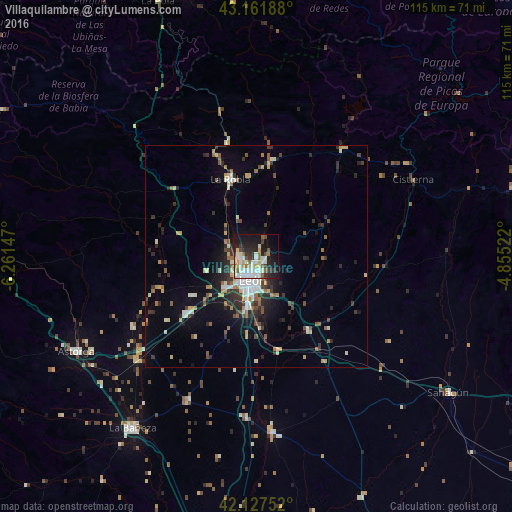
Analysis of Villaquilambre night lights 2016
Square area 10x10 km:
 9.39%
9.39%90-99
13.64%80-89
5.15%70-79
3.03%60-69
3.18%50-59
5.3%40-49
3.64%30-39
5.76%20-29
12.58%10-19
25.91%0-9
12.42%Square area 50x50 km:
1.08%90-99
1.68%80-89
1.01%70-79
0.82%60-69
0.98%50-59
1.12%40-49
1.03%30-39
1.79%20-29
2.78%10-19
4.38%0-9
83.33%Clear (daylight) street map image can be seen on geolist.org.
Map coordinates:
43° 9' 42.8" North, 6° 15' 41.3" West
42° 38' 48.7" North, 5° 33' 30.1" West
42° 7' 39.1" North, 4° 51' 18.8" West
Some cities around Villaquilambre sort by population:
• León
5.3 km =3.3 mi,  190°
190°
• San Andrés del Rabanedo
6.2 km =3.9 mi,  230°
230°
• Pola de Laviana
66.6 km =41.4 mi,  359°
359°
• Pola de Lena
61.3 km =38.1 mi,  338°
338°
• Ruayer
45.2 km =28.1 mi,  0°
0°
• Astorga
45.8 km =28.5 mi,  242°
242°
• La Bañeza
47.5 km =29.5 mi,  215°
215°
• Guardo
60.1 km =37.3 mi,  74°
74°
3105148 (p: 17,013)
Sources (retrieved 2019-11-25):
» Earth at Night: Flat Maps 2012, 2016