La Bañeza night lights from space
Night Light of La Bañeza (Castille and León) from space (Spain) Src. Average luminocity for 10x10km area is 18.647% and for 50x50km: 4.9638%.
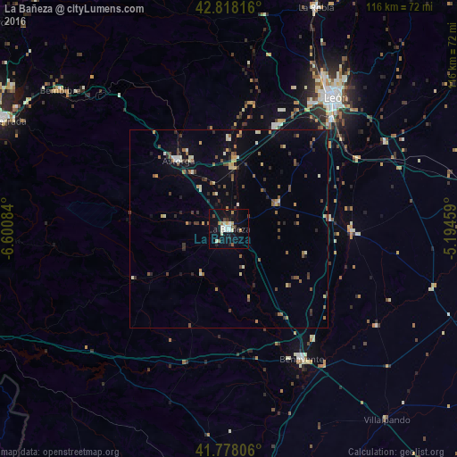
Analysis of La Bañeza night lights 2016
Square area 10x10 km:
 2.42%
2.42%90-99
5.45%80-89
1.21%70-79
1.21%60-69
2.42%50-59
0.61%40-49
2.27%30-39
1.36%20-29
1.21%10-19
19.55%0-9
62.27%Square area 50x50 km:
0.18%90-99
0.85%80-89
0.49%70-79
0.52%60-69
0.59%50-59
0.93%40-49
0.85%30-39
0.67%20-29
0.84%10-19
2.19%0-9
91.9%Clear (daylight) street map image can be seen on geolist.org.
Map coordinates:
42° 49' 5.4" North, 6° 36' 3" West
42° 18' 0.9" North, 5° 53' 51.8" West
41° 46' 41" North, 5° 11' 40.5" West
Some cities around La Bañeza sort by population:
• León
42.8 km =26.6 mi,  38°
38°
• Ponferrada
63.5 km =39.5 mi,  295°
295°
• San Andrés del Rabanedo
41.6 km =25.8 mi,  33°
33°
• Benavente
37.7 km =23.4 mi,  151°
151°
• Villaquilambre
47.5 km =29.5 mi, 35°
• Astorga
21.9 km =13.6 mi,  323°
323°
• Bembibre
55.2 km =34.3 mi,  309°
309°
• Cacabelos
75.5 km =46.9 mi, 296°
3119979 (p: 11,057)
Sources (retrieved 2019-11-25):
» Earth at Night: Flat Maps 2012, 2016