Siwa Oasis night lights from space
Night Light of Siwa Oasis (Matruh) from space (Egypt) Src. Average luminocity for 10x10km area is 31.5218% and for 50x50km: 1.4526%.
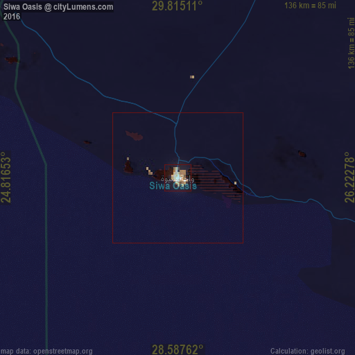
Analysis of Siwa Oasis night lights 2016
Square area 10x10 km:
 3.97%
3.97%90-99
4.76%80-89
4.76%70-79
1.98%60-69
11.51%50-59
3.97%40-49
1.59%30-39
0.79%20-29
1.98%10-19
34.72%0-9
29.96%Square area 50x50 km:
0.15%90-99
0.18%80-89
0.18%70-79
0.13%60-69
0.46%50-59
0.18%40-49
0.12%30-39
0.03%20-29
0.07%10-19
1.35%0-9
97.16%Clear (daylight) street map image can be seen on geolist.org.
Map coordinates:
29° 48' 54.4" North, 24° 48' 59.5" East
29° 12' 11.5" North, 25° 31' 10.7" East
28° 35' 15.4" North, 26° 13' 22" East
Some cities around Siwa Oasis sort by population:
• Alexandria
477.3 km =296.6 mi,  62°
62°
• Tobruk, LY
354.2 km =220.1 mi,  334°
334°
• Darnah, LY
482.2 km =299.6 mi, 325°
• Mersa Matruh
290.4 km =180.4 mi,  34°
34°
• Al Bawīţī
339.6 km =211 mi,  106°
106°
• Al Bardīyah, LY
286.9 km =178.3 mi,  351°
351°
• Al ‘Alamayn
377 km =234.3 mi, 61°
• Awjilah, LY
411.1 km =255.4 mi,  268°
268°
347863 (p: 7,000)
Sources (retrieved 2019-11-25):
» Earth at Night: Flat Maps 2012, 2016