Al ‘Alamayn night lights from space
Night Light of Al ‘Alamayn (Matruh) from space (Egypt) Src. Average luminocity for 10x10km area is 39.6608% and for 50x50km: 6.5545%.
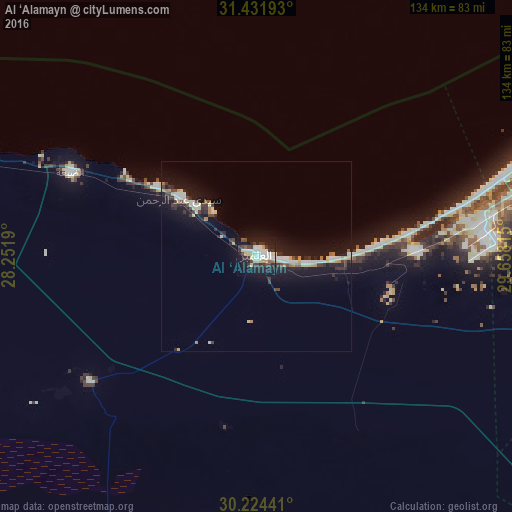
Analysis of Al ‘Alamayn night lights 2016
Square area 10x10 km:
 9.44%
9.44%90-99
9.44%80-89
4.9%70-79
2.27%60-69
0.87%50-59
2.8%40-49
2.1%30-39
10.66%20-29
11.19%10-19
36.89%0-9
9.44%Square area 50x50 km:
0.91%90-99
1.01%80-89
1.11%70-79
0.43%60-69
0.38%50-59
0.32%40-49
0.62%30-39
1.4%20-29
1.72%10-19
8.21%0-9
83.89%Clear (daylight) street map image can be seen on geolist.org.
Map coordinates:
31° 25' 54.9" North, 28° 15' 6.8" East
30° 49' 48.3" North, 28° 57' 18.1" East
30° 13' 27.9" North, 29° 39' 29.3" East
Some cities around Al ‘Alamayn sort by population:
• Alexandria
100.5 km =62.4 mi,  65°
65°
• Kafr ad Dawwār
117 km =72.7 mi, 73°
• Damanhūr
146.1 km =90.8 mi,  81°
81°
• Idkū
138.5 km =86.1 mi, 67°
• Ḩawsh ‘Īsá
127.8 km =79.4 mi,  85°
85°
• Rosetta
152.9 km =95 mi, 65°
• Abū al Maţāmīr
116.7 km =72.5 mi, 85°
• Ad Dilinjāt
150.9 km =93.8 mi, 90°
361612 (p: 7,400)
Sources (retrieved 2019-11-25):
» Earth at Night: Flat Maps 2012, 2016