Weeze night lights from space
Night Light of Weeze (North Rhine-Westphalia) from space (Germany) Src. Average luminocity for 10x10km area is 9.4706% and for 50x50km: 8.9874%.
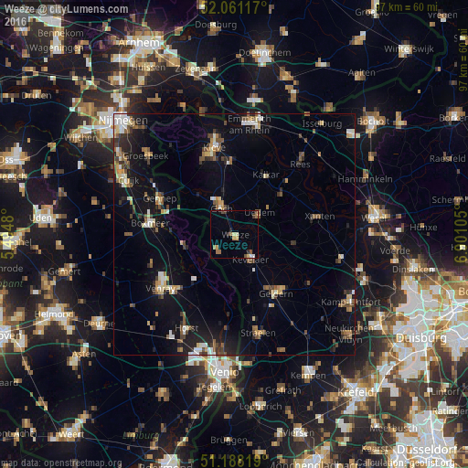
Analysis of Weeze night lights 2016
Square area 10x10 km:
 0.67%
0.67%90-99
0.4%80-89
1.6%70-79
1.6%60-69
2.27%50-59
1.6%40-49
0.94%30-39
1.47%20-29
1.2%10-19
0.53%0-9
87.7%Square area 50x50 km:
0.88%90-99
1.15%80-89
0.95%70-79
0.82%60-69
1.03%50-59
1.62%40-49
1.46%30-39
1.11%20-29
1.95%10-19
6.89%0-9
82.14%Clear (daylight) street map image can be seen on geolist.org.
Map coordinates:
52° 3' 40.2" North, 5° 29' 41.3" East
51° 37' 36.4" North, 6° 11' 52.5" East
51° 11' 17.5" North, 6° 54' 3.8" East
Some cities around Weeze sort by population:
• Geldern
14.8 km =9.2 mi,  144°
144°
• Goch
6.4 km =4 mi,  335°
335°
• Kevelaer
5.9 km =3.7 mi,  146°
146°
• Kalkar
14 km =8.7 mi,  27°
27°
• Boxmeer, NL
17.4 km =10.8 mi,  277°
277°
• Arcen, NL
16.7 km =10.4 mi,  184°
184°
• Uedem
6.8 km =4.2 mi,  50°
50°
• Sonsbeck
12.7 km =7.9 mi,  99°
99°
2813410 (p: 10,131)
Sources (retrieved 2019-11-25):
» Earth at Night: Flat Maps 2012, 2016