Uedem night lights from space
Night Light of Uedem (North Rhine-Westphalia) from space (Germany) Src. Average luminocity for 10x10km area is 3.7031% and for 50x50km: 9.1882%.
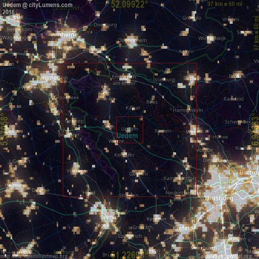
Analysis of Uedem night lights 2016
Square area 10x10 km:
100  0%
0%
90-99 0%
80-89 0.56%
70-79 0%
60-69 1.12%
50-59 1.4%
40-49 0.84%
30-39 1.12%
20-29 0.28%
10-19 0%
0-9 94.68%
0%90-99
0%80-89
0.56%70-79
0%60-69
1.12%50-59
1.4%40-49
0.84%30-39
1.12%20-29
0.28%10-19
0%0-9
94.68%Square area 50x50 km:
100 0.78%
90-99 1.01%
80-89 1.01%
70-79 0.91%
60-69 1.15%
50-59 1.65%
40-49 1.59%
30-39 1%
20-29 1.19%
10-19 8.09%
0-9 81.6%
0.78%90-99
1.01%80-89
1.01%70-79
0.91%60-69
1.15%50-59
1.65%40-49
1.59%30-39
1%20-29
1.19%10-19
8.09%0-9
81.6%Clear (daylight) street map image can be seen on geolist.org.
Map coordinates:
52° 5' 57.2" North, 5° 34' 14.1" East
51° 39' 54.7" North, 6° 16' 25.4" East
51° 13' 37.1" North, 6° 58' 36.6" East
Some cities around Uedem sort by population:
• Kleve
16.5 km =10.3 mi,  325°
325°
• Goch
8.1 km =5 mi,  280°
280°
• Kevelaer
9.4 km =5.8 mi,  191°
191°
• Rees
13.8 km =8.6 mi,  38°
38°
• Xanten
12.4 km =7.7 mi,  93°
93°
• Kalkar
8.3 km =5.2 mi,  8°
8°
• Weeze
6.8 km =4.2 mi,  230°
230°
• Sonsbeck
9.7 km =6 mi,  131°
131°
2820465 (p: 8,619)
Sources (retrieved 2019-11-25):
» Earth at Night: Flat Maps 2012, 2016