Arcen night lights from space
Night Light of Arcen (Limburg) from space (Netherlands) Src. Average luminocity for 10x10km area is 3.6898% and for 50x50km: 11.625%.
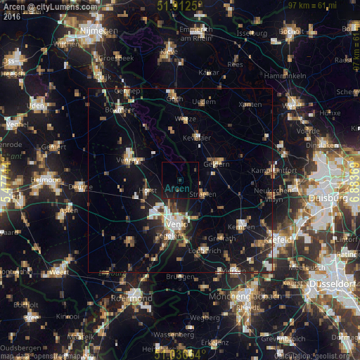
Analysis of Arcen night lights 2016
Square area 10x10 km:
 0%
0%90-99
0%80-89
0%70-79
0%60-69
0%50-59
0%40-49
1.07%30-39
0%20-29
0.94%10-19
10.96%0-9
87.03%Square area 50x50 km:
1.31%90-99
1.68%80-89
1.04%70-79
1.07%60-69
1.1%50-59
2.04%40-49
2.09%30-39
1.34%20-29
3.28%10-19
9.48%0-9
75.58%Clear (daylight) street map image can be seen on geolist.org.
Map coordinates:
51° 54' 45" North, 5° 28' 38.8" East
51° 28' 36" North, 6° 10' 50" East
51° 2' 11.9" North, 6° 53' 1.3" East
Some cities around Arcen sort by population:
• Venlo
11.9 km =7.4 mi,  184°
184°
• Venray
15.2 km =9.4 mi,  290°
290°
• Geldern, DE
11 km =6.8 mi,  64°
64°
• Kevelaer, DE
12.6 km =7.8 mi,  21°
21°
• Tegelen
15.1 km =9.4 mi,  191°
191°
• Straelen, DE
7.1 km =4.4 mi,  123°
123°
• Wachtendonk, DE
13.3 km =8.3 mi, 124°
• Sevenum
12.2 km =7.6 mi,  234°
234°
2759684 (p: 8,793)
Sources (retrieved 2019-11-25):
» Earth at Night: Flat Maps 2012, 2016