Tönisvorst night lights from space
Night Light of Tönisvorst (North Rhine-Westphalia) from space (Germany) Src. Average luminocity for 10x10km area is 37.1737% and for 50x50km: 33.5513%.
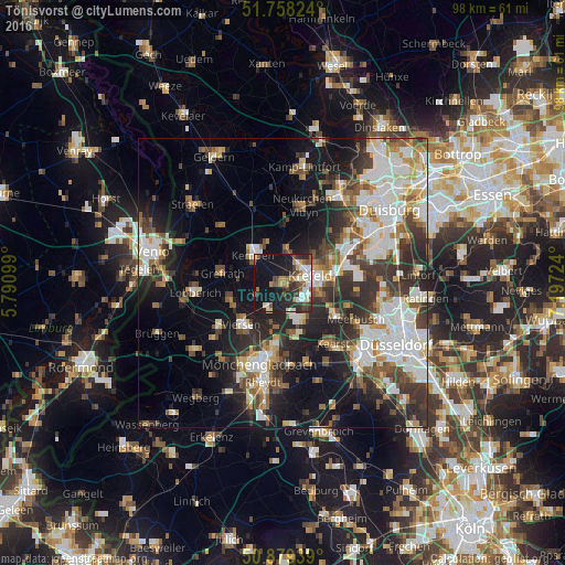

Analysis of Tönisvorst night lights 2016
Square area 10x10 km:
 5.04%
5.04%90-99
8.4%80-89
2.8%70-79
3.92%60-69
3.08%50-59
6.44%40-49
6.58%30-39
3.92%20-29
14.43%10-19
37.68%0-9
7.7%Square area 50x50 km:
7.12%90-99
7.68%80-89
2.66%70-79
3.27%60-69
3.36%50-59
4.33%40-49
5.01%30-39
5.99%20-29
9.07%10-19
14.44%0-9
37.07%Clear (daylight) street map image can be seen on geolist.org.
Map coordinates:
51° 45' 29.7" North, 5° 47' 27.6" East
51° 19' 15.3" North, 6° 29' 38.8" East
50° 52' 45.8" North, 7° 11' 50.1" East
Some cities around Tönisvorst sort by population:
• Krefeld
4.5 km =2.8 mi,  67°
67°
• Viersen
10.1 km =6.3 mi,  223°
223°
• Willich
7.4 km =4.6 mi,  149°
149°
• Kaarst
13.4 km =8.3 mi,  139°
139°
• Kempen
7.1 km =4.4 mi,  312°
312°
• Korschenbroich
14.5 km =9 mi,  174°
174°
• Grefrath
10.8 km =6.7 mi,  279°
279°
• Wachtendonk
14.6 km =9.1 mi, 312°
2821899 (p: 30,296)
Sources (retrieved 2019-11-25):
» Earth at Night: Flat Maps 2012, 2016