Grefrath night lights from space
Night Light of Grefrath (North Rhine-Westphalia) from space (Germany) Src. Average luminocity for 10x10km area is 12.1345% and for 50x50km: 22.9553%.
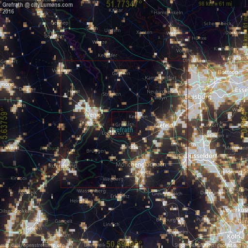
Analysis of Grefrath night lights 2016
Square area 10x10 km:
 0.28%
0.28%90-99
0.98%80-89
1.26%70-79
0.84%60-69
2.1%50-59
1.96%40-49
4.34%30-39
0%20-29
0.7%10-19
5.32%0-9
82.21%Square area 50x50 km:
2.93%90-99
3.87%80-89
2.06%70-79
2.19%60-69
2.44%50-59
3.55%40-49
4.35%30-39
3.94%20-29
8.41%10-19
17.38%0-9
48.88%Clear (daylight) street map image can be seen on geolist.org.
Map coordinates:
51° 46' 24.5" North, 5° 38' 15.3" East
51° 20' 10.7" North, 6° 20' 26.6" East
50° 53' 41.7" North, 7° 2' 37.8" East
Some cities around Grefrath sort by population:
• Venlo, NL
12.6 km =7.8 mi,  287°
287°
• Viersen
9.8 km =6.1 mi,  157°
157°
• Nettetal
4.5 km =2.8 mi,  241°
241°
• Kempen
6.2 km =3.9 mi,  60°
60°
• Tönisvorst
10.8 km =6.7 mi,  99°
99°
• Tegelen, NL
14.2 km =8.8 mi,  273°
273°
• Straelen
12.8 km =8 mi,  336°
336°
• Wachtendonk
8.1 km =5 mi,  359°
359°
2917816 (p: 16,016)
Sources (retrieved 2019-11-25):
» Earth at Night: Flat Maps 2012, 2016