Wachtendonk night lights from space
Night Light of Wachtendonk (North Rhine-Westphalia) from space (Germany) Src. Average luminocity for 10x10km area is 5.2115% and for 50x50km: 20.955%.
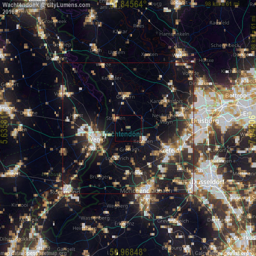
Analysis of Wachtendonk night lights 2016
Square area 10x10 km:
 0%
0%90-99
0%80-89
0.28%70-79
0.84%60-69
1.12%50-59
1.68%40-49
1.68%30-39
0%20-29
0.28%10-19
0%0-9
94.12%Square area 50x50 km:
2.83%90-99
3.46%80-89
2.02%70-79
2.04%60-69
2.02%50-59
3.23%40-49
3.75%30-39
3.5%20-29
7.69%10-19
15.4%0-9
54.05%Clear (daylight) street map image can be seen on geolist.org.
Map coordinates:
51° 50' 44.3" North, 5° 38' 8.9" East
51° 24' 33" North, 6° 20' 20.2" East
50° 58' 6.5" North, 7° 2' 31.4" East
Some cities around Wachtendonk sort by population:
• Venlo, NL
12.6 km =7.8 mi,  249°
249°
• Nettetal
11 km =6.8 mi,  200°
200°
• Kempen
7.4 km =4.6 mi,  132°
132°
• Geldern
12.3 km =7.6 mi,  355°
355°
• Grefrath
8.1 km =5 mi,  179°
179°
• Straelen
6.2 km =3.9 mi,  305°
305°
• Arcen, NL
13.3 km =8.3 mi,  304°
304°
• Rheurdt
10.9 km =6.8 mi,  54°
54°
2815651 (p: 7,823)
Sources (retrieved 2019-11-25):
» Earth at Night: Flat Maps 2012, 2016