Stelle night lights from space
Night Light of Stelle (Lower Saxony) from space (Germany) Src. Average luminocity for 10x10km area is 7.1534% and for 50x50km: 17.3426%.
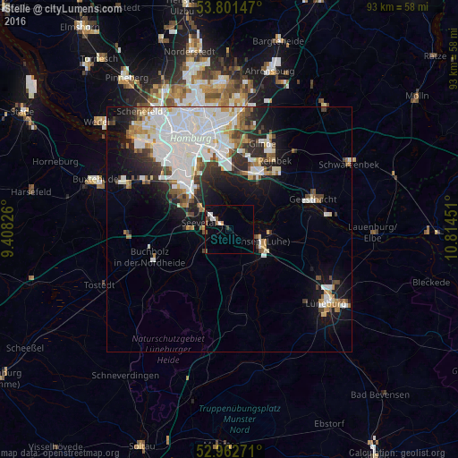
Analysis of Stelle night lights 2016
Square area 10x10 km:
 1.46%
1.46%90-99
1.19%80-89
0%70-79
0.53%60-69
0.53%50-59
1.85%40-49
0.79%30-39
1.06%20-29
0%10-19
2.38%0-9
90.21%Square area 50x50 km:
6.18%90-99
3.93%80-89
1.09%70-79
1.28%60-69
1.49%50-59
1.36%40-49
1.48%30-39
1.58%20-29
2.99%10-19
6.71%0-9
71.9%Clear (daylight) street map image can be seen on geolist.org.
Map coordinates:
53° 48' 5.3" North, 9° 24' 29.7" East
53° 23' 3" North, 10° 6' 41" East
52° 57' 45.8" North, 10° 48' 52.2" East
Some cities around Stelle sort by population:
• Harburg
12 km =7.5 mi,  315°
315°
• Bergedorf
13.6 km =8.5 mi,  34°
34°
• Seevetal
9.8 km =6.1 mi,  280°
280°
• Buchholz in der Nordheide
17.4 km =10.8 mi,  248°
248°
• Winsen
7.4 km =4.6 mi,  113°
113°
• Reinbek
17.4 km =10.8 mi, 31°
• Wentorf bei Hamburg
15.8 km =9.8 mi,  35°
35°
• Jesteburg
13.4 km =8.3 mi,  231°
231°
2827574 (p: 11,073)
Sources (retrieved 2019-11-25):
» Earth at Night: Flat Maps 2012, 2016