Jesteburg night lights from space
Night Light of Jesteburg (Lower Saxony) from space (Germany) Src. Average luminocity for 10x10km area is 1.0505% and for 50x50km: 8.5478%.
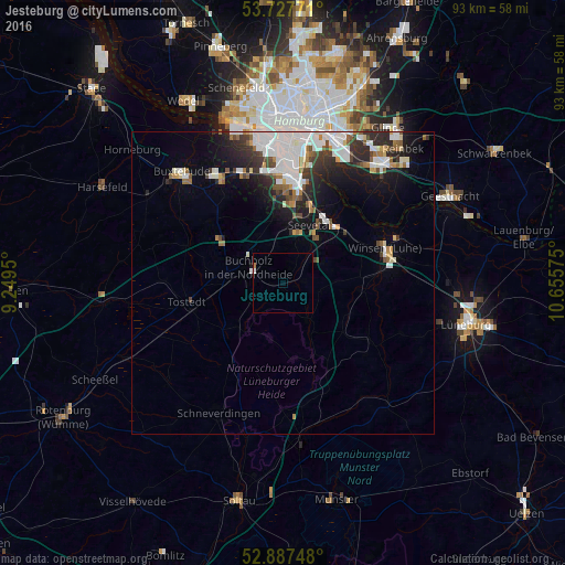
Analysis of Jesteburg night lights 2016
Square area 10x10 km:
 0.13%
0.13%90-99
0.38%80-89
0%70-79
0%60-69
0.51%50-59
0%40-49
0%30-39
0%20-29
0%10-19
0%0-9
98.99%Square area 50x50 km:
2.54%90-99
1.77%80-89
0.42%70-79
0.55%60-69
0.82%50-59
0.87%40-49
0.78%30-39
1.17%20-29
2.35%10-19
4.08%0-9
84.65%Clear (daylight) street map image can be seen on geolist.org.
Map coordinates:
53° 43' 39.8" North, 9° 14' 58.2" East
53° 18' 34.8" North, 9° 57' 9.4" East
52° 53' 14.9" North, 10° 39' 20.7" East
Some cities around Jesteburg sort by population:
• Harburg
16.9 km =10.5 mi,  7°
7°
• Seevetal
10.1 km =6.3 mi, 5°
• Buchholz in der Nordheide
5.9 km =3.7 mi,  288°
288°
• Winsen
18.1 km =11.2 mi,  72°
72°
• Neu Wulmstorf
20.2 km =12.6 mi,  329°
329°
• Schneverdingen
23.9 km =14.9 mi,  206°
206°
• Tostedt
16 km =9.9 mi,  259°
259°
• Stelle
13.4 km =8.3 mi,  51°
51°
2894945 (p: 7,066)
Sources (retrieved 2019-11-25):
» Earth at Night: Flat Maps 2012, 2016