Penig night lights from space
Night Light of Penig (Saxony) from space (Germany) Src. Average luminocity for 10x10km area is 1.2647% and for 50x50km: 8.6707%.
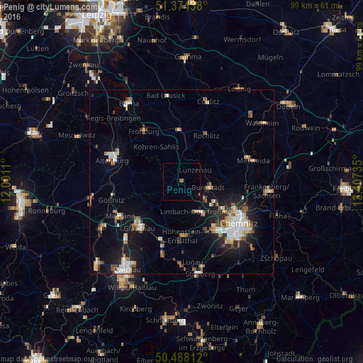
Analysis of Penig night lights 2016
Square area 10x10 km:
 0%
0%90-99
0%80-89
0%70-79
0%60-69
0.28%50-59
1.12%40-49
0%30-39
0%20-29
0%10-19
0%0-9
98.6%Square area 50x50 km:
1.23%90-99
1.64%80-89
0.91%70-79
0.85%60-69
1.11%50-59
1.3%40-49
0.77%30-39
0.88%20-29
2.02%10-19
5.76%0-9
83.53%Clear (daylight) street map image can be seen on geolist.org.
Map coordinates:
51° 22' 27.8" North, 12° 0' 4" East
50° 56' 0.1" North, 12° 42' 15.2" East
50° 29' 17.2" North, 13° 24' 26.5" East
Some cities around Penig sort by population:
• Limbach-Oberfrohna
9.2 km =5.7 mi,  154°
154°
• Hohenstein-Ernstthal
14.8 km =9.2 mi,  177°
177°
• Burgstädt
7.5 km =4.7 mi,  107°
107°
• Rochlitz
14.5 km =9 mi,  26°
26°
• Oberlungwitz
16.8 km =10.4 mi, 179°
• Geithain
13.6 km =8.5 mi,  357°
357°
• Callenberg
10.5 km =6.5 mi,  208°
208°
• Lunzenau
4.9 km =3 mi,  48°
48°
2854967 (p: 10,557)
Sources (retrieved 2019-11-25):
» Earth at Night: Flat Maps 2012, 2016