Callenberg night lights from space
Night Light of Callenberg (Saxony) from space (Germany) Src. Average luminocity for 10x10km area is 0.9776% and for 50x50km: 9.1594%.
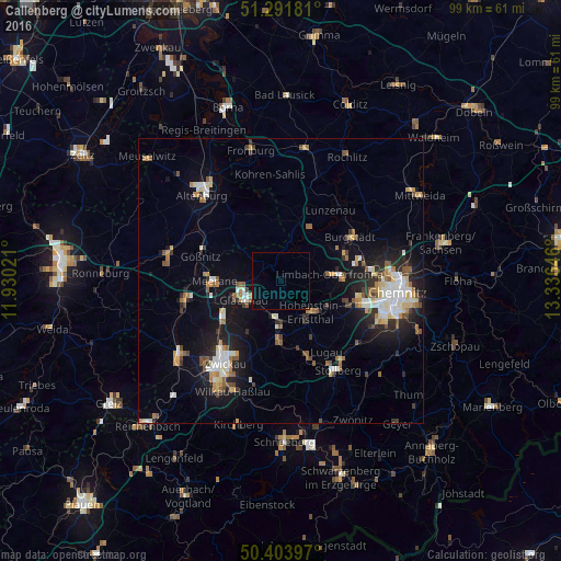
Analysis of Callenberg night lights 2016
Square area 10x10 km:
 0%
0%90-99
0%80-89
0%70-79
0%60-69
0%50-59
0%40-49
0%30-39
0%20-29
0%10-19
0%0-9
100%Square area 50x50 km:
1.27%90-99
1.62%80-89
0.98%70-79
1%60-69
1.1%50-59
1.4%40-49
0.78%30-39
0.95%20-29
2.16%10-19
6.69%0-9
82.05%Clear (daylight) street map image can be seen on geolist.org.
Map coordinates:
51° 17' 30.5" North, 11° 55' 48.8" East
50° 51' 0" North, 12° 37' 60" East
50° 24' 14.3" North, 13° 20' 11.3" East
Some cities around Callenberg sort by population:
• Limbach-Oberfrohna
9.1 km =5.7 mi,  83°
83°
• Glauchau
7.1 km =4.4 mi,  241°
241°
• Meerane
11.8 km =7.3 mi,  268°
268°
• Hohenstein-Ernstthal
7.8 km =4.8 mi,  134°
134°
• Lichtenstein
10.4 km =6.5 mi,  181°
181°
• Mülsen
12.1 km =7.5 mi,  202°
202°
• Penig
10.5 km =6.5 mi,  28°
28°
• Oberlungwitz
9.2 km =5.7 mi,  145°
145°
2940397 (p: 5,763)
Sources (retrieved 2019-11-25):
» Earth at Night: Flat Maps 2012, 2016