Oberlungwitz night lights from space
Night Light of Oberlungwitz (Saxony) from space (Germany) Src. Average luminocity for 10x10km area is 4.2227% and for 50x50km: 9.9417%.
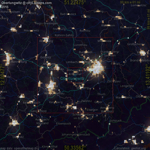
Analysis of Oberlungwitz night lights 2016
Square area 10x10 km:
 0%
0%90-99
0%80-89
0.28%70-79
0.28%60-69
1.12%50-59
0.56%40-49
0.28%30-39
1.96%20-29
0.98%10-19
1.54%0-9
93%Square area 50x50 km:
1.36%90-99
1.72%80-89
1.08%70-79
1.05%60-69
1.32%50-59
1.47%40-49
0.92%30-39
1.02%20-29
2.29%10-19
6.78%0-9
80.98%Clear (daylight) street map image can be seen on geolist.org.
Map coordinates:
51° 13' 29.1" North, 12° 0' 17.2" East
50° 46' 56.3" North, 12° 42' 28.4" East
50° 20' 8.2" North, 13° 24' 39.7" East
Some cities around Oberlungwitz sort by population:
• Limbach-Oberfrohna
9.3 km =5.8 mi,  23°
23°
• Hohenstein-Ernstthal
2.1 km =1.3 mi,  9°
9°
• Lichtenstein
6.2 km =3.9 mi,  242°
242°
• Stollberg
9.5 km =5.9 mi,  147°
147°
• Mülsen
10.6 km =6.6 mi,  250°
250°
• Oelsnitz
6.3 km =3.9 mi,  184°
184°
• Lugau
5.7 km =3.5 mi, 149°
• Callenberg
9.2 km =5.7 mi,  325°
325°
2859843 (p: 6,794)
Sources (retrieved 2019-11-25):
» Earth at Night: Flat Maps 2012, 2016