Burgstädt night lights from space
Night Light of Burgstädt (Saxony) from space (Germany) Src. Average luminocity for 10x10km area is 10.909% and for 50x50km: 8.1156%.
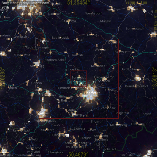
Analysis of Burgstädt night lights 2016
Square area 10x10 km:
 0.84%
0.84%90-99
0.56%80-89
1.26%70-79
1.26%60-69
2.24%50-59
0.84%40-49
1.12%30-39
1.26%20-29
3.22%10-19
12.04%0-9
75.35%Square area 50x50 km:
1.17%90-99
1.51%80-89
0.99%70-79
0.77%60-69
1.03%50-59
1.24%40-49
0.79%30-39
0.8%20-29
2.05%10-19
5.27%0-9
84.37%Clear (daylight) street map image can be seen on geolist.org.
Map coordinates:
51° 21' 16.3" North, 12° 6' 10.4" East
50° 54' 48" North, 12° 48' 21.6" East
50° 28' 4.4" North, 13° 30' 32.9" East
Some cities around Burgstädt sort by population:
• Chemnitz
12.2 km =7.6 mi,  134°
134°
• Limbach-Oberfrohna
6.8 km =4.2 mi,  207°
207°
• Mittweida
14.4 km =8.9 mi,  55°
55°
• Hohenstein-Ernstthal
14.1 km =8.8 mi, 207°
• Penig
7.5 km =4.7 mi,  287°
287°
• Rochlitz
15.2 km =9.4 mi,  357°
357°
• Callenberg
14 km =8.7 mi,  239°
239°
• Lunzenau
6.5 km =4 mi,  327°
327°
2941150 (p: 12,477)
Sources (retrieved 2019-11-25):
» Earth at Night: Flat Maps 2012, 2016