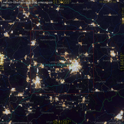
Limbach-Oberfrohna night lights from space
Night Light of Limbach-Oberfrohna (Saxony) from space (Germany) Src. Average luminocity for 10x10km area is 13.0322% and for 50x50km: 8.8006%.
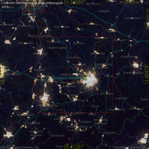
Analysis of Limbach-Oberfrohna night lights 2016
Square area 10x10 km:
 0.7%
0.7%90-99
1.26%80-89
1.12%70-79
2.66%60-69
2.38%50-59
1.4%40-49
1.4%30-39
0.98%20-29
2.24%10-19
18.07%0-9
67.79%Square area 50x50 km:
1.24%90-99
1.61%80-89
1.01%70-79
0.82%60-69
1.06%50-59
1.24%40-49
0.83%30-39
0.87%20-29
2.15%10-19
6.64%0-9
82.53%Clear (daylight) street map image can be seen on geolist.org.
Map coordinates:
51° 18' 2" North, 12° 3' 30.7" East
50° 51' 31.8" North, 12° 45' 41.9" East
50° 24' 46.3" North, 13° 27' 53.2" East
Some cities around Limbach-Oberfrohna sort by population:
• Chemnitz
12 km =7.5 mi,  102°
102°
• Hohenstein-Ernstthal
7.3 km =4.5 mi,  207°
207°
• Burgstädt
6.8 km =4.2 mi,  27°
27°
• Penig
9.2 km =5.7 mi,  334°
334°
• Neukirchen
11.5 km =7.1 mi,  139°
139°
• Oberlungwitz
9.3 km =5.8 mi,  203°
203°
• Callenberg
9.1 km =5.7 mi,  263°
263°
• Lunzenau
11.6 km =7.2 mi,  358°
358°
2877673 (p: 27,056)
Sources (retrieved 2019-11-25):
» Earth at Night: Flat Maps 2012, 2016