Neukirchen night lights from space
Night Light of Neukirchen (Saxony) from space (Germany) Src. Average luminocity for 10x10km area is 35.2661% and for 50x50km: 7.3098%.
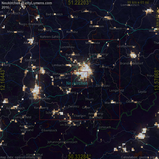
Analysis of Neukirchen night lights 2016
Square area 10x10 km:
 9.1%
9.1%90-99
8.96%80-89
4.2%70-79
2.52%60-69
1.68%50-59
2.94%40-49
2.52%30-39
3.08%20-29
10.36%10-19
22.97%0-9
31.65%Square area 50x50 km:
0.91%90-99
1.24%80-89
0.9%70-79
0.61%60-69
1.04%50-59
1.12%40-49
0.84%30-39
0.8%20-29
1.97%10-19
4.41%0-9
86.16%Clear (daylight) street map image can be seen on geolist.org.
Map coordinates:
51° 13' 19.3" North, 12° 9' 51.9" East
50° 46' 46.4" North, 12° 52' 3.2" East
50° 19' 58.2" North, 13° 34' 14.4" East
Some cities around Neukirchen sort by population:
• Chemnitz
7.6 km =4.7 mi,  34°
34°
• Hohenstein-Ernstthal
11.1 km =6.9 mi,  282°
282°
• Stollberg
9.9 km =6.2 mi,  218°
218°
• Lugau
9.5 km =5.9 mi,  241°
241°
• Thalheim
8.8 km =5.5 mi,  188°
188°
• Burkhardtsdorf
6.2 km =3.9 mi,  146°
146°
• Oberlungwitz
11.2 km =7 mi,  271°
271°
• Jahnsdorf
3.9 km =2.4 mi, 193°
2864750 (p: 7,517)
Sources (retrieved 2019-11-25):
» Earth at Night: Flat Maps 2012, 2016