Mülsen night lights from space
Night Light of Mülsen (Saxony) from space (Germany) Src. Average luminocity for 10x10km area is 14.0321% and for 50x50km: 8.487%.
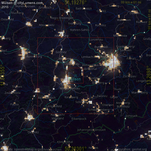
Analysis of Mülsen night lights 2016
Square area 10x10 km:
 2.14%
2.14%90-99
2.01%80-89
0.13%70-79
1.87%60-69
1.34%50-59
3.34%40-49
0.67%30-39
0%20-29
4.28%10-19
20.99%0-9
63.24%Square area 50x50 km:
1%90-99
1.26%80-89
0.84%70-79
1.04%60-69
1.18%50-59
1.48%40-49
0.83%30-39
0.95%20-29
1.66%10-19
5.77%0-9
83.99%Clear (daylight) street map image can be seen on geolist.org.
Map coordinates:
51° 11' 33.9" North, 11° 51' 48.8" East
50° 45' 0" North, 12° 34' 0" East
50° 18' 10.8" North, 13° 16' 11.3" East
Some cities around Mülsen sort by population:
• Zwickau
6.1 km =3.8 mi,  245°
245°
• Glauchau
7.9 km =4.9 mi,  348°
348°
• Hohenstein-Ernstthal
11.7 km =7.3 mi,  61°
61°
• Lichtenstein
4.5 km =2.8 mi,  80°
80°
• Oelsnitz
9.8 km =6.1 mi,  105°
105°
• Wilkau-Haßlau
9.1 km =5.7 mi,  203°
203°
• Reinsdorf
5.9 km =3.7 mi,  187°
187°
• Oberlungwitz
10.6 km =6.6 mi,  70°
70°
2867753 (p: 12,489)
Sources (retrieved 2019-11-25):
» Earth at Night: Flat Maps 2012, 2016