Lichtenstein night lights from space
Night Light of Lichtenstein (Saxony) from space (Germany) Src. Average luminocity for 10x10km area is 6.4906% and for 50x50km: 9.6732%.
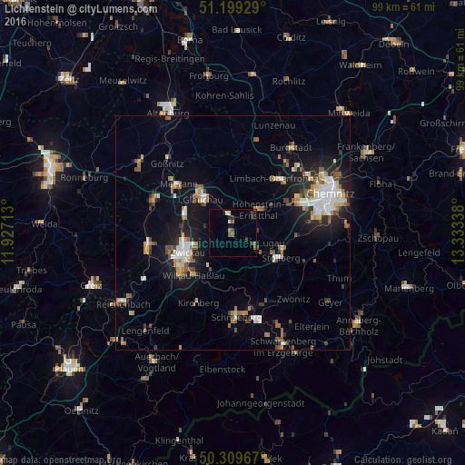
Analysis of Lichtenstein night lights 2016
Square area 10x10 km:
 0.27%
0.27%90-99
1.2%80-89
0.13%70-79
0.13%60-69
0.67%50-59
2.67%40-49
1.07%30-39
1.07%20-29
1.74%10-19
1.87%0-9
89.17%Square area 50x50 km:
1.27%90-99
1.61%80-89
0.98%70-79
1.06%60-69
1.3%50-59
1.55%40-49
0.92%30-39
1%20-29
2.33%10-19
6.55%0-9
81.44%Clear (daylight) street map image can be seen on geolist.org.
Map coordinates:
51° 11' 57.4" North, 11° 55' 37.7" East
50° 45' 23.7" North, 12° 37' 48.9" East
50° 18' 34.8" North, 13° 20' 0.2" East
Some cities around Lichtenstein sort by population:
• Glauchau
9.2 km =5.7 mi,  319°
319°
• Hohenstein-Ernstthal
7.6 km =4.7 mi,  49°
49°
• Mülsen
4.5 km =2.8 mi,  260°
260°
• Oelsnitz
6 km =3.7 mi,  124°
124°
• Reinsdorf
8.4 km =5.2 mi,  218°
218°
• Lugau
8.6 km =5.3 mi,  103°
103°
• Oberlungwitz
6.2 km =3.9 mi,  62°
62°
• Callenberg
10.4 km =6.5 mi,  1°
1°
2878037 (p: 13,612)
Sources (retrieved 2019-11-25):
» Earth at Night: Flat Maps 2012, 2016