Mittweida night lights from space
Night Light of Mittweida (Saxony) from space (Germany) Src. Average luminocity for 10x10km area is 3.3583% and for 50x50km: 5.7653%.
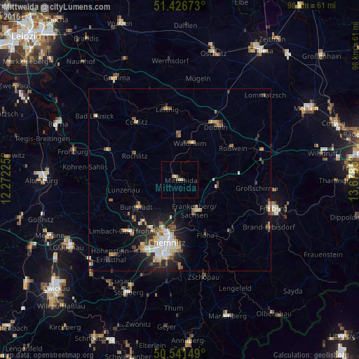
Analysis of Mittweida night lights 2016
Square area 10x10 km:
 0%
0%90-99
0%80-89
1.07%70-79
1.2%60-69
0.4%50-59
0.13%40-49
0.67%30-39
0.27%20-29
0%10-19
0.53%0-9
95.72%Square area 50x50 km:
0.73%90-99
1.04%80-89
0.81%70-79
0.55%60-69
0.86%50-59
0.79%40-49
0.72%30-39
0.64%20-29
1.7%10-19
3.13%0-9
89.03%Clear (daylight) street map image can be seen on geolist.org.
Map coordinates:
51° 25' 36.2" North, 12° 16' 20.1" East
50° 59' 10.4" North, 12° 58' 31.3" East
50° 32' 29.4" North, 13° 40' 42.6" East
Some cities around Mittweida sort by population:
• Frankenberg
9.3 km =5.8 mi,  150°
150°
• Burgstädt
14.4 km =8.9 mi,  235°
235°
• Hainichen
10.5 km =6.5 mi,  99°
99°
• Waldheim
10.1 km =6.3 mi,  17°
17°
• Hartha
12.5 km =7.8 mi,  359°
359°
• Rochlitz
14.3 km =8.9 mi,  299°
299°
• Niederwiesa
13.6 km =8.5 mi,  167°
167°
• Geringswalde
11.1 km =6.9 mi,  334°
334°
2870318 (p: 16,619)
Sources (retrieved 2019-11-25):
» Earth at Night: Flat Maps 2012, 2016