Toumodi night lights from space
Night Light of Toumodi (Lacs) from space (Ivory Coast) Src. Average luminocity for 10x10km area is 13.2468% and for 50x50km: 1.829%.
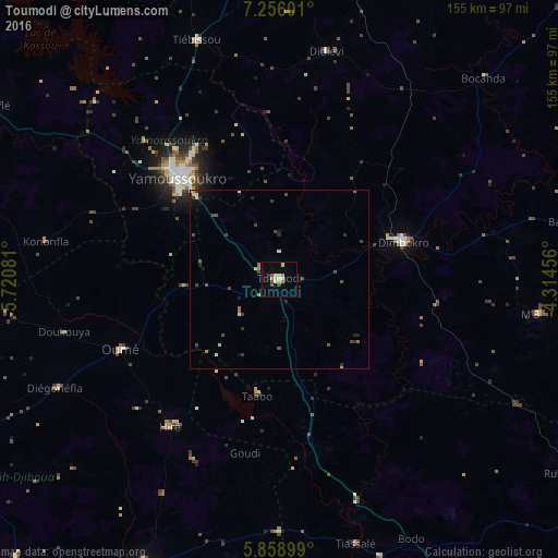

Analysis of Toumodi night lights 2016
Square area 10x10 km:
 0.43%
0.43%90-99
2.38%80-89
4.11%70-79
0.87%60-69
1.52%50-59
1.3%40-49
1.52%30-39
1.3%20-29
0.43%10-19
1.95%0-9
84.2%Square area 50x50 km:
0.02%90-99
0.25%80-89
0.34%70-79
0.11%60-69
0.28%50-59
0.22%40-49
0.54%30-39
0.5%20-29
0.28%10-19
0.59%0-9
96.88%Clear (daylight) street map image can be seen on geolist.org.
Map coordinates:
7° 15' 21.6" North, 5° 43' 14.9" West
6° 33' 28.8" North, 5° 1' 3.7" West
5° 51' 32.4" North, 4° 18' 52.4" West
Some cities around Toumodi sort by population:
• Yamoussoukro
40.9 km =25.4 mi,  315°
315°
• Divo
88.5 km =55 mi,  205°
205°
• Dimbokro
35.9 km =22.3 mi,  74°
74°
• Bouaflé
93.5 km =58.1 mi,  300°
300°
• Oumé
48.3 km =30 mi,  246°
246°
• Tiassalé
76.4 km =47.5 mi,  163°
163°
• Bongouanou
90.5 km =56.2 mi,  83°
83°
• Bocanda
80.1 km =49.8 mi,  45°
45°
2280316 (p: 39,005)
Sources (retrieved 2019-11-25):
» Earth at Night: Flat Maps 2012, 2016