Valley East night lights from space
Night Light of Valley East (Ontario) from space (Canada) Src. Average luminocity for 10x10km area is 12.5213% and for 50x50km: 5.9583%.
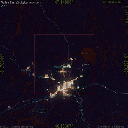
Analysis of Valley East night lights 2016
Square area 10x10 km:
 0%
0%90-99
1.28%80-89
1.42%70-79
0.71%60-69
3.13%50-59
2.56%40-49
4.55%30-39
0%20-29
1.99%10-19
6.96%0-9
77.41%Square area 50x50 km:
0.49%90-99
1.21%80-89
0.56%70-79
0.56%60-69
0.96%50-59
0.81%40-49
1.17%30-39
0.55%20-29
1.83%10-19
3.8%0-9
88.06%Clear (daylight) street map image can be seen on geolist.org.
Map coordinates:
47° 8' 53.1" North, 81° 42' 12.3" West
46° 40' 3.8" North, 81° 0' 1" West
46° 10' 59.1" North, 80° 17' 49.8" West
Some cities around Valley East sort by population:
• Greater Sudbury
19.8 km =12.3 mi,  177°
177°
• North Bay
123.7 km =76.9 mi,  108°
108°
• Rayside-Balfour
17.1 km =10.6 mi,  247°
247°
• Elliot Lake
128.9 km =80.1 mi,  255°
255°
• Temiskaming Shores
133.8 km =83.1 mi,  46°
46°
• Kirkland Lake
179.5 km =111.5 mi,  23°
23°
• Parry Sound
164.6 km =102.3 mi,  153°
153°
• Lively
28.5 km =17.7 mi,  203°
203°
12070764 (p: 17,451)
Sources (retrieved 2019-11-25):
» Earth at Night: Flat Maps 2012, 2016