Lively night lights from space
Night Light of Lively (Ontario) from space (Canada) Src. Average luminocity for 10x10km area is 16.2991% and for 50x50km: 6.7388%.
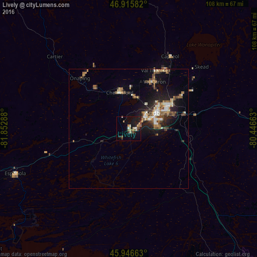
Analysis of Lively night lights 2016
Square area 10x10 km:
 0.3%
0.3%90-99
3.87%80-89
1.04%70-79
2.53%60-69
2.23%50-59
2.83%40-49
2.08%30-39
1.49%20-29
3.72%10-19
13.69%0-9
66.22%Square area 50x50 km:
0.5%90-99
1.31%80-89
0.56%70-79
0.62%60-69
1.09%50-59
1.04%40-49
1.4%30-39
0.64%20-29
2.09%10-19
4.92%0-9
85.83%Clear (daylight) street map image can be seen on geolist.org.
Map coordinates:
46° 54' 57" North, 81° 51' 10.4" West
46° 26' 0.2" North, 81° 8' 59.1" West
45° 56' 47.9" North, 80° 26' 47.9" West
Some cities around Lively sort by population:
• Greater Sudbury
13.8 km =8.6 mi,  62°
62°
• North Bay
129.8 km =80.7 mi,  95°
95°
• Huntsville
193.3 km =120.1 mi,  129°
129°
• Valley East
28.5 km =17.7 mi,  23°
23°
• Rayside-Balfour
20 km =12.4 mi,  347°
347°
• Elliot Lake
113.9 km =70.8 mi,  267°
267°
• Temiskaming Shores
160.5 km =99.7 mi,  42°
42°
• Parry Sound
148.4 km =92.2 mi,  144°
144°
6057842 (p: 5,608)
Sources (retrieved 2019-11-25):
» Earth at Night: Flat Maps 2012, 2016