Rayside-Balfour night lights from space
Night Light of Rayside-Balfour (Ontario) from space (Canada) Src. Average luminocity for 10x10km area is 8.0469% and for 50x50km: 6.6787%.
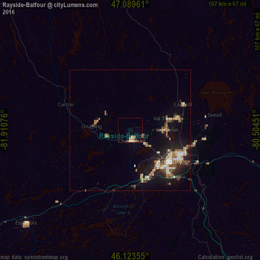
Analysis of Rayside-Balfour night lights 2016
Square area 10x10 km:
 0.14%
0.14%90-99
0.99%80-89
2.7%70-79
0.71%60-69
1.56%50-59
1.14%40-49
0.85%30-39
0.71%20-29
1.7%10-19
0.43%0-9
89.06%Square area 50x50 km:
0.5%90-99
1.29%80-89
0.57%70-79
0.63%60-69
1.11%50-59
0.98%40-49
1.38%30-39
0.61%20-29
2.1%10-19
4.79%0-9
86.04%Clear (daylight) street map image can be seen on geolist.org.
Map coordinates:
47° 5' 22.6" North, 81° 54' 38.7" West
46° 36' 31.4" North, 81° 12' 27.5" West
46° 7' 24.8" North, 80° 30' 16.2" West
Some cities around Rayside-Balfour sort by population:
• Greater Sudbury
21.2 km =13.2 mi,  128°
128°
• North Bay
137.3 km =85.3 mi,  103°
103°
• Valley East
17.1 km =10.6 mi,  67°
67°
• Elliot Lake
112 km =69.6 mi,  257°
257°
• Temiskaming Shores
149.9 km =93.1 mi,  48°
48°
• Kirkland Lake
192.2 km =119.4 mi,  27°
27°
• Parry Sound
167 km =103.8 mi,  147°
147°
• Lively
20 km =12.4 mi,  167°
167°
6117731 (p: 16,050)
Sources (retrieved 2019-11-25):
» Earth at Night: Flat Maps 2012, 2016