Piracanjuba night lights from space
Night Light of Piracanjuba (Goiás) from space (Brazil) Src. Average luminocity for 10x10km area is 15.469% and for 50x50km: 0.8377%.
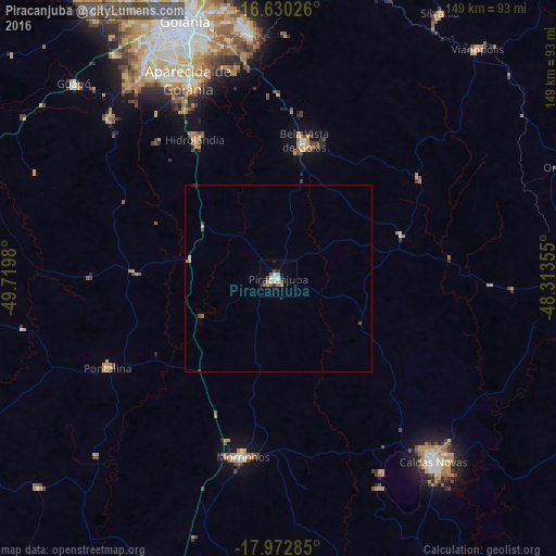
Analysis of Piracanjuba night lights 2016
Square area 10x10 km:
 2.89%
2.89%90-99
2.07%80-89
0.21%70-79
3.51%60-69
1.45%50-59
3.1%40-49
1.65%30-39
1.45%20-29
2.27%10-19
2.07%0-9
79.34%Square area 50x50 km:
0.11%90-99
0.08%80-89
0.01%70-79
0.22%60-69
0.13%50-59
0.13%40-49
0.14%30-39
0.13%20-29
0.12%10-19
0.08%0-9
98.85%Clear (daylight) street map image can be seen on geolist.org.
Map coordinates:
16° 37' 48.9" South, 49° 43' 11.3" West
17° 18' 10" South, 49° 1' 0" West
17° 58' 22.3" South, 48° 18' 48.8" West
Some cities around Piracanjuba sort by population:
• Goiânia
73.8 km =45.9 mi,  340°
340°
• Aparecida de Goiânia
58.5 km =36.4 mi, 335°
• Caldas Novas
64.1 km =39.8 mi,  139°
139°
• Senador Canedo
66.6 km =41.4 mi,  352°
352°
• Morrinhos
48.4 km =30.1 mi,  190°
190°
• Bela Vista de Goiás
37.3 km =23.2 mi,  10°
10°
• Pontalina
51.9 km =32.2 mi,  241°
241°
• Hidrolândia
44 km =27.3 mi,  329°
329°
3453659 (p: 16,736)
Sources (retrieved 2019-11-25):
» Earth at Night: Flat Maps 2012, 2016