Hidrolândia night lights from space
Night Light of Hidrolândia (Goiás) from space (Brazil) Src. Average luminocity for 10x10km area is 15.9351% and for 50x50km: 14.899%.
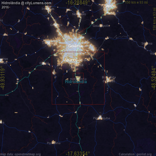
Analysis of Hidrolândia night lights 2016
Square area 10x10 km:
 0%
0%90-99
0.87%80-89
1.52%70-79
4.55%60-69
5.19%50-59
0.87%40-49
4.33%30-39
0.65%20-29
1.52%10-19
3.25%0-9
77.27%Square area 50x50 km:
1.93%90-99
2.64%80-89
1.92%70-79
3.66%60-69
2.04%50-59
1.87%40-49
2.6%30-39
1.52%20-29
2.77%10-19
5.17%0-9
73.89%Clear (daylight) street map image can be seen on geolist.org.
Map coordinates:
16° 17' 18.6" South, 49° 55' 52.3" West
16° 57' 44" South, 49° 13' 41" West
17° 38' 0.7" South, 48° 31' 29.8" West
Some cities around Hidrolândia sort by population:
• Goiânia
31.7 km =19.7 mi,  355°
355°
• Aparecida de Goiânia
15.5 km =9.6 mi,  353°
353°
• Trindade
44.5 km =27.7 mi,  321°
321°
• Senador Canedo
31.7 km =19.7 mi,  26°
26°
• Piracanjuba
44 km =27.3 mi,  149°
149°
• Bela Vista de Goiás
29.2 km =18.1 mi,  92°
92°
• Goianápolis
54.7 km =34 mi,  23°
23°
• Guapó
35.5 km =22.1 mi,  294°
294°
3461677 (p: 7,082)
Sources (retrieved 2019-11-25):
» Earth at Night: Flat Maps 2012, 2016