Guapó night lights from space
Night Light of Guapó (Goiás) from space (Brazil) Src. Average luminocity for 10x10km area is 11.1645% and for 50x50km: 16.5593%.
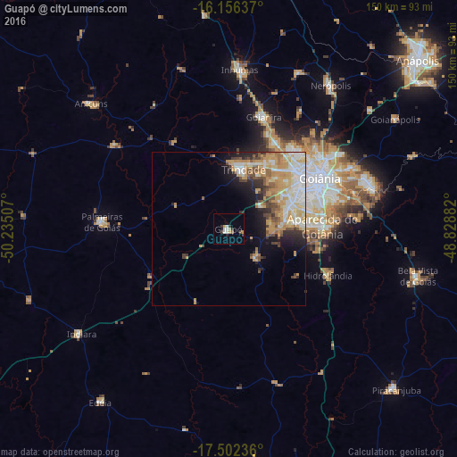
Analysis of Guapó night lights 2016
Square area 10x10 km:
 0.87%
0.87%90-99
3.46%80-89
0%70-79
2.16%60-69
0.87%50-59
0.87%40-49
0.87%30-39
2.81%20-29
1.95%10-19
0%0-9
86.15%Square area 50x50 km:
2.63%90-99
3.26%80-89
2.56%70-79
4.66%60-69
1.83%50-59
1.54%40-49
2.07%30-39
1.31%20-29
2.35%10-19
4.14%0-9
73.66%Clear (daylight) street map image can be seen on geolist.org.
Map coordinates:
16° 9' 22.9" South, 50° 14' 6.3" West
16° 49' 50" South, 49° 31' 55" West
17° 30' 8.5" South, 48° 49' 43.8" West
Some cities around Guapó sort by population:
• Goiânia
34.1 km =21.2 mi,  60°
60°
• Aparecida de Goiânia
30.7 km =19.1 mi,  88°
88°
• Trindade
20.7 km =12.9 mi,  12°
12°
• Senador Canedo
48.7 km =30.3 mi,  73°
73°
• Inhumas
52.7 km =32.7 mi,  4°
4°
• Goianira
38.8 km =24.1 mi,  16°
16°
• Palmeiras de Goiás
42 km =26.1 mi,  273°
273°
• Hidrolândia
35.5 km =22.1 mi,  114°
114°
3461943 (p: 10,075)
Sources (retrieved 2019-11-25):
» Earth at Night: Flat Maps 2012, 2016