Goianápolis night lights from space
Night Light of Goianápolis (Goiás) from space (Brazil) Src. Average luminocity for 10x10km area is 6.7665% and for 50x50km: 18.5784%.
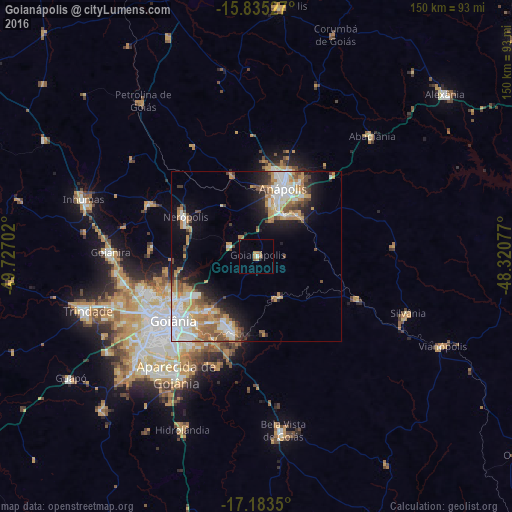
Analysis of Goianápolis night lights 2016
Square area 10x10 km:
 0%
0%90-99
0.83%80-89
0%70-79
2.89%60-69
1.45%50-59
1.45%40-49
0%30-39
0.21%20-29
0.62%10-19
0.41%0-9
92.15%Square area 50x50 km:
3.81%90-99
3.65%80-89
1.47%70-79
4.61%60-69
2.08%50-59
2.1%40-49
2.07%30-39
1.36%20-29
3.11%10-19
7.04%0-9
68.68%Clear (daylight) street map image can be seen on geolist.org.
Map coordinates:
15° 50' 7" South, 49° 43' 37.3" West
16° 30' 38" South, 49° 1' 26" West
17° 11' 0.6" South, 48° 19' 14.8" West
Some cities around Goianápolis sort by population:
• Aparecida de Goiânia
41.9 km =26 mi,  213°
213°
• Anápolis
21.8 km =13.5 mi,  20°
20°
• Trindade
51.9 km =32.2 mi,  252°
252°
• Senador Canedo
23.2 km =14.4 mi,  198°
198°
• Nerópolis
23.8 km =14.8 mi,  299°
299°
• Bela Vista de Goiás
51.9 km =32.2 mi,  171°
171°
• Silvânia
47.3 km =29.4 mi,  110°
110°
• Abadiânia
48 km =29.8 mi,  44°
44°
3462383 (p: 10,114)
Sources (retrieved 2019-11-25):
» Earth at Night: Flat Maps 2012, 2016