Centralina night lights from space
Night Light of Centralina (Minas Gerais) from space (Brazil) Src. Average luminocity for 10x10km area is 6.2562% and for 50x50km: 3.7139%.
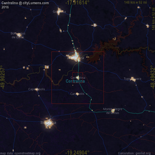
Analysis of Centralina night lights 2016
Square area 10x10 km:
 0.21%
0.21%90-99
0.62%80-89
0%70-79
3.1%60-69
1.45%50-59
1.24%40-49
0%30-39
0.83%20-29
0.62%10-19
1.03%0-9
90.91%Square area 50x50 km:
0.62%90-99
0.63%80-89
0.21%70-79
0.81%60-69
0.54%50-59
0.2%40-49
0.52%30-39
0.36%20-29
0.96%10-19
2.56%0-9
92.58%Clear (daylight) street map image can be seen on geolist.org.
Map coordinates:
17° 54' 58.1" South, 49° 54' 9.3" West
18° 35' 2" South, 49° 11' 58" West
19° 14' 56.5" South, 48° 29' 46.8" West
Some cities around Centralina sort by population:
• Ituiutaba
51.5 km =32 mi,  212°
212°
• Itumbiara
18.4 km =11.4 mi,  354°
354°
• Goiatuba
65.6 km =40.8 mi, 345°
• Tupaciguara
52.1 km =32.4 mi,  91°
91°
• Prata
85.5 km =53.1 mi,  160°
160°
• Capinópolis
40.5 km =25.2 mi,  254°
254°
• Monte Alegre de Minas
46.3 km =28.8 mi,  133°
133°
• Buriti Alegre
52.1 km =32.4 mi,  18°
18°
3466462 (p: 9,497)
Sources (retrieved 2019-11-25):
» Earth at Night: Flat Maps 2012, 2016