Capinópolis night lights from space
Night Light of Capinópolis (Minas Gerais) from space (Brazil) Src. Average luminocity for 10x10km area is 5.8636% and for 50x50km: 0.9082%.
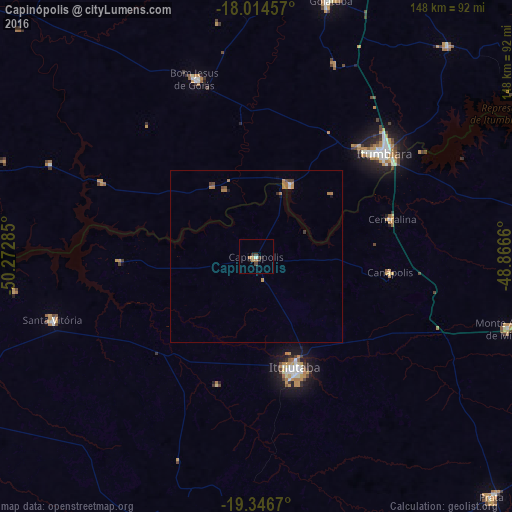
Analysis of Capinópolis night lights 2016
Square area 10x10 km:
 0%
0%90-99
0.83%80-89
0.21%70-79
1.45%60-69
1.65%50-59
0%40-49
2.48%30-39
1.03%20-29
1.24%10-19
1.03%0-9
90.08%Square area 50x50 km:
0.04%90-99
0.06%80-89
0.01%70-79
0.22%60-69
0.42%50-59
0.03%40-49
0.28%30-39
0.09%20-29
0.07%10-19
0.14%0-9
98.64%Clear (daylight) street map image can be seen on geolist.org.
Map coordinates:
18° 0' 52.5" South, 50° 16' 22.3" West
18° 40' 55" South, 49° 34' 11" West
19° 20' 48.1" South, 48° 51' 59.8" West
Some cities around Capinópolis sort by population:
• Ituiutaba
34.4 km =21.4 mi,  160°
160°
• Itumbiara
47.4 km =29.5 mi,  51°
51°
• Goiatuba
77.8 km =48.3 mi,  16°
16°
• Tupaciguara
91.7 km =57 mi,  83°
83°
• Monte Alegre de Minas
75.5 km =46.9 mi,  106°
106°
• Santa Vitória
60.6 km =37.7 mi,  253°
253°
• Centralina
40.5 km =25.2 mi,  74°
74°
• Buriti Alegre
82.2 km =51.1 mi,  42°
42°
3467263 (p: 12,486)
Sources (retrieved 2019-11-25):
» Earth at Night: Flat Maps 2012, 2016