Monte Alegre de Minas night lights from space
Night Light of Monte Alegre de Minas (Minas Gerais) from space (Brazil) Src. Average luminocity for 10x10km area is 9.1515% and for 50x50km: 0.4491%.
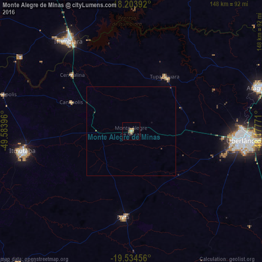
Analysis of Monte Alegre de Minas night lights 2016
Square area 10x10 km:
 0.65%
0.65%90-99
0.87%80-89
0.65%70-79
3.9%60-69
0.87%50-59
1.73%40-49
1.73%30-39
0.87%20-29
0%10-19
0.43%0-9
88.31%Square area 50x50 km:
0.02%90-99
0.03%80-89
0.02%70-79
0.16%60-69
0.05%50-59
0.07%40-49
0.18%30-39
0.03%20-29
0%10-19
0.05%0-9
99.38%Clear (daylight) street map image can be seen on geolist.org.
Map coordinates:
18° 12' 14.1" South, 49° 35' 2.3" West
18° 52' 14" South, 48° 52' 51" West
19° 32' 4.4" South, 48° 10' 39.8" West
Some cities around Monte Alegre de Minas sort by population:
• Uberlândia
63.7 km =39.6 mi,  94°
94°
• Araguari
77.1 km =47.9 mi,  71°
71°
• Ituiutaba
62.2 km =38.6 mi,  259°
259°
• Itumbiara
61.3 km =38.1 mi,  324°
324°
• Tupaciguara
36.1 km =22.4 mi,  30°
30°
• Prata
48.8 km =30.3 mi,  185°
185°
• Capinópolis
75.5 km =46.9 mi,  286°
286°
• Centralina
46.3 km =28.8 mi,  313°
313°
3456880 (p: 12,451)
Sources (retrieved 2019-11-25):
» Earth at Night: Flat Maps 2012, 2016