Buriti Alegre night lights from space
Night Light of Buriti Alegre (Goiás) from space (Brazil) Src. Average luminocity for 10x10km area is 8.7208% and for 50x50km: 0.9478%.
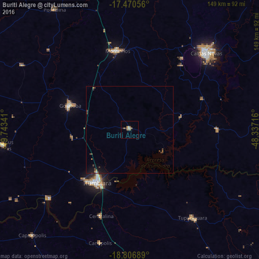
Analysis of Buriti Alegre night lights 2016
Square area 10x10 km:
 0.43%
0.43%90-99
1.08%80-89
0.22%70-79
3.46%60-69
1.73%50-59
2.6%40-49
0.65%30-39
0.22%20-29
0.22%10-19
0.65%0-9
88.74%Square area 50x50 km:
0.04%90-99
0.06%80-89
0.01%70-79
0.24%60-69
0.13%50-59
0.1%40-49
0.39%30-39
0.17%20-29
0.07%10-19
0.88%0-9
97.91%Clear (daylight) street map image can be seen on geolist.org.
Map coordinates:
17° 28' 14" South, 49° 44' 36.3" West
18° 8' 24" South, 49° 2' 25" West
18° 48' 24.8" South, 48° 20' 13.8" West
Some cities around Buriti Alegre sort by population:
• Itumbiara
36.1 km =22.4 mi,  210°
210°
• Caldas Novas
62 km =38.5 mi,  44°
44°
• Morrinhos
45.9 km =28.5 mi,  352°
352°
• Goiatuba
36.1 km =22.4 mi,  293°
293°
• Tupaciguara
61.5 km =38.2 mi,  144°
144°
• Pontalina
80.8 km =50.2 mi,  327°
327°
• Capinópolis
82.2 km =51.1 mi,  222°
222°
• Centralina
52.1 km =32.4 mi,  198°
198°
3468745 (p: 9,427)
Sources (retrieved 2019-11-25):
» Earth at Night: Flat Maps 2012, 2016