Carlos Barbosa night lights from space
Night Light of Carlos Barbosa (Rio Grande do Sul) from space (Brazil) Src. Average luminocity for 10x10km area is 33.3485% and for 50x50km: 9.3156%.
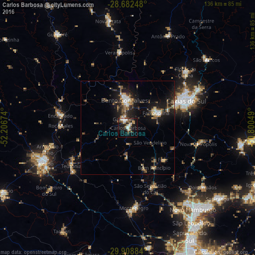
Analysis of Carlos Barbosa night lights 2016
Square area 10x10 km:
 6.25%
6.25%90-99
6.25%80-89
4.36%70-79
2.08%60-69
2.65%50-59
6.25%40-49
3.41%30-39
5.68%20-29
5.87%10-19
30.11%0-9
27.08%Square area 50x50 km:
0.89%90-99
1.01%80-89
0.91%70-79
0.95%60-69
1.17%50-59
1.83%40-49
1.19%30-39
2.32%20-29
2.79%10-19
8.17%0-9
78.77%Clear (daylight) street map image can be seen on geolist.org.
Map coordinates:
28° 40' 56.9" South, 52° 12' 24.3" West
29° 17' 51" South, 51° 30' 13" West
29° 54' 31.8" South, 50° 48' 1.8" West
Some cities around Carlos Barbosa sort by population:
• Caxias do Sul
34.6 km =21.5 mi,  65°
65°
• Bento Gonçalves
14.1 km =8.8 mi,  353°
353°
• Farroupilha
17.1 km =10.6 mi,  61°
61°
• Garibaldi
5.4 km =3.4 mi,  327°
327°
• Teutônia
33.8 km =21 mi,  240°
240°
• São Sebastião do Caí
34.5 km =21.4 mi,  158°
158°
• Encantado
36.2 km =22.5 mi,  280°
280°
• Nova Petrópolis
38.7 km =24 mi,  103°
103°
3466933 (p: 19,105)
Sources (retrieved 2019-11-25):
» Earth at Night: Flat Maps 2012, 2016