Encantado night lights from space
Night Light of Encantado (Rio Grande do Sul) from space (Brazil) Src. Average luminocity for 10x10km area is 20.631% and for 50x50km: 5.4554%.
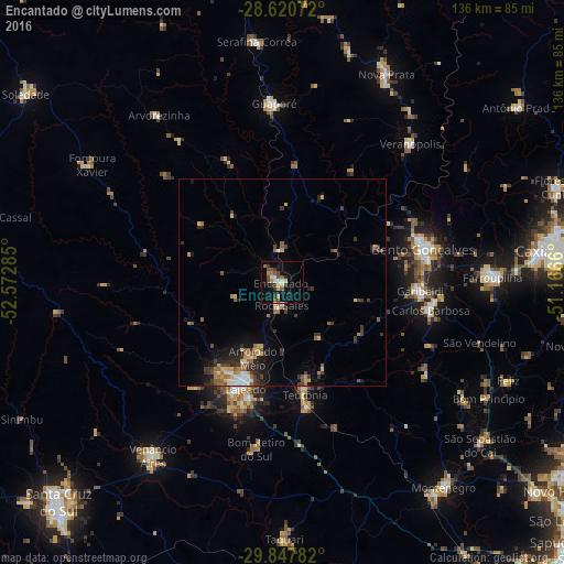
Analysis of Encantado night lights 2016
Square area 10x10 km:
 1.19%
1.19%90-99
2.98%80-89
2.18%70-79
2.58%60-69
1.59%50-59
3.97%40-49
5.16%30-39
4.96%20-29
1.98%10-19
19.25%0-9
54.17%Square area 50x50 km:
0.47%90-99
0.6%80-89
0.67%70-79
0.67%60-69
0.84%50-59
1.01%40-49
0.72%30-39
1.43%20-29
1.29%10-19
2.84%0-9
89.46%Clear (daylight) street map image can be seen on geolist.org.
Map coordinates:
28° 37' 14.6" South, 52° 34' 22.3" West
29° 14' 10" South, 51° 52' 11" West
29° 50' 52.2" South, 51° 9' 59.8" West
Some cities around Encantado sort by population:
• Bento Gonçalves
34.8 km =21.6 mi,  78°
78°
• Lajeado
27.2 km =16.9 mi,  199°
199°
• Garibaldi
32.7 km =20.3 mi,  93°
93°
• Teutônia
24.4 km =15.2 mi,  165°
165°
• Guaporé
43.5 km =27 mi,  357°
357°
• Veranópolis
45.6 km =28.3 mi,  43°
43°
• Carlos Barbosa
36.2 km =22.5 mi,  100°
100°
• Arroio do Meio
19.7 km =12.2 mi, 201°
3464274 (p: 16,637)
Sources (retrieved 2019-11-25):
» Earth at Night: Flat Maps 2012, 2016