Nova Petrópolis night lights from space
Night Light of Nova Petrópolis (Rio Grande do Sul) from space (Brazil) Src. Average luminocity for 10x10km area is 14.7784% and for 50x50km: 10.8319%.
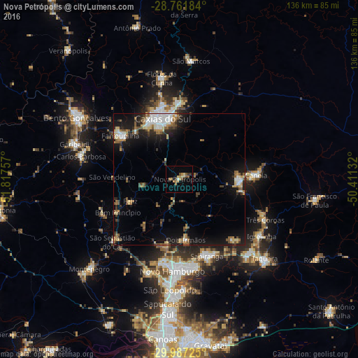
Analysis of Nova Petrópolis night lights 2016
Square area 10x10 km:
 0.19%
0.19%90-99
0.57%80-89
3.03%70-79
3.41%60-69
3.41%50-59
3.03%40-49
1.33%30-39
1.7%20-29
0.38%10-19
0.95%0-9
82.01%Square area 50x50 km:
1.43%90-99
1.58%80-89
1.33%70-79
1.09%60-69
1.62%50-59
1.87%40-49
1.09%30-39
1.67%20-29
2.08%10-19
8.03%0-9
78.21%Clear (daylight) street map image can be seen on geolist.org.
Map coordinates:
28° 45' 42.6" South, 51° 49' 3.3" West
29° 22' 35" South, 51° 6' 52" West
29° 59' 14.1" South, 50° 24' 40.8" West
Some cities around Nova Petrópolis sort by population:
• Caxias do Sul
24 km =14.9 mi,  344°
344°
• Novo Hamburgo
33.6 km =20.9 mi,  182°
182°
• Sapiranga
30.9 km =19.2 mi,  160°
160°
• Farroupilha
28.2 km =17.5 mi,  306°
306°
• Estância Velha
30.8 km =19.1 mi,  190°
190°
• Canela
29.2 km =18.1 mi,  85°
85°
• São Sebastião do Caí
34.4 km =21.4 mi,  227°
227°
• Ivoti
24.3 km =15.1 mi, 190°
3456127 (p: 16,049)
Sources (retrieved 2019-11-25):
» Earth at Night: Flat Maps 2012, 2016