São Sebastião do Caí night lights from space
Night Light of São Sebastião do Caí (Rio Grande do Sul) from space (Brazil) Src. Average luminocity for 10x10km area is 15.3571% and for 50x50km: 11.9917%.
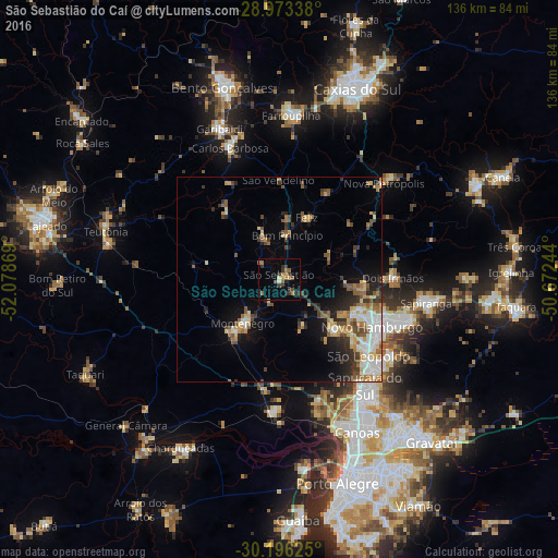
Analysis of São Sebastião do Caí night lights 2016
Square area 10x10 km:
 0.4%
0.4%90-99
0.4%80-89
1.59%70-79
0.2%60-69
5.95%50-59
3.37%40-49
1.19%30-39
5.75%20-29
4.76%10-19
0.4%0-9
75.99%Square area 50x50 km:
1.67%90-99
1.58%80-89
1.7%70-79
1.59%60-69
1.68%50-59
2.01%40-49
1.82%30-39
1.88%20-29
2.51%10-19
4.62%0-9
78.93%Clear (daylight) street map image can be seen on geolist.org.
Map coordinates:
28° 58' 24.2" South, 52° 4' 43.3" West
29° 35' 12" South, 51° 22' 32" West
30° 11' 46.5" South, 50° 40' 20.8" West
Some cities around São Sebastião do Caí sort by population:
• Novo Hamburgo
25.8 km =16 mi,  113°
113°
• São Leopoldo
29.3 km =18.2 mi,  131°
131°
• Montenegro
14 km =8.7 mi,  216°
216°
• Estância Velha
20.7 km =12.9 mi, 109°
• Portão
18.2 km =11.3 mi, 134°
• Carlos Barbosa
34.5 km =21.4 mi,  338°
338°
• Ivoti
20.8 km =12.9 mi,  91°
91°
• Nova Petrópolis
34.4 km =21.4 mi,  47°
47°
3448227 (p: 19,012)
Sources (retrieved 2019-11-25):
» Earth at Night: Flat Maps 2012, 2016