Teutônia night lights from space
Night Light of Teutônia (Rio Grande do Sul) from space (Brazil) Src. Average luminocity for 10x10km area is 16.8409% and for 50x50km: 8.2748%.

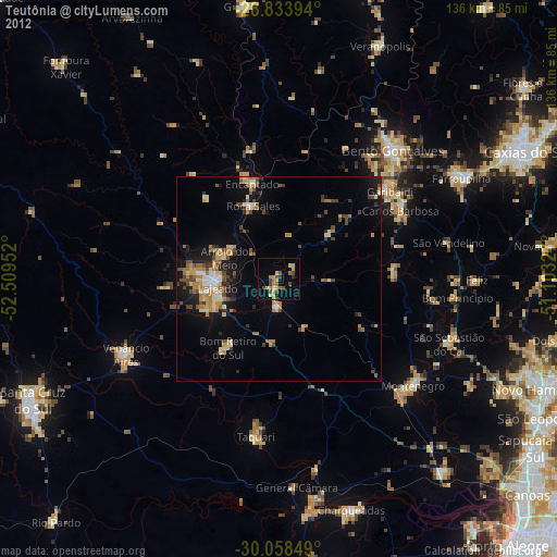
Analysis of Teutônia night lights 2016
Square area 10x10 km:
 0%
0%90-99
0.95%80-89
3.22%70-79
3.03%60-69
2.27%50-59
2.84%40-49
3.79%30-39
5.11%20-29
0.95%10-19
10.42%0-9
67.42%Square area 50x50 km:
0.62%90-99
0.93%80-89
1.05%70-79
1.18%60-69
1.19%50-59
1.55%40-49
0.97%30-39
2.07%20-29
2.03%10-19
5.36%0-9
83.05%Clear (daylight) street map image can be seen on geolist.org.
Map coordinates:
28° 50' 2.2" South, 52° 30' 34.3" West
29° 26' 53" South, 51° 48' 23" West
30° 3' 30.6" South, 51° 6' 11.8" West
Some cities around Teutônia sort by population:
• Bento Gonçalves
41.5 km =25.8 mi,  42°
42°
• Lajeado
15.2 km =9.4 mi,  262°
262°
• Venâncio Aires
41.2 km =25.6 mi,  244°
244°
• Garibaldi
34 km =21.1 mi,  51°
51°
• Taquari
39.5 km =24.5 mi,  188°
188°
• Carlos Barbosa
33.8 km =21 mi,  60°
60°
• Encantado
24.4 km =15.2 mi,  345°
345°
• Arroio do Meio
14.4 km =8.9 mi,  291°
291°
3446556 (p: 21,834)
Sources (retrieved 2019-11-25):
» Earth at Night: Flat Maps 2012, 2016