Welkenraedt night lights from space
Night Light of Welkenraedt (Wallonia) from space (Belgium) Src. Average luminocity for 10x10km area is 22.1898% and for 50x50km: 20.1752%.
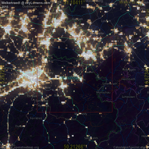
Analysis of Welkenraedt night lights 2016
Square area 10x10 km:
 2.27%
2.27%90-99
3.88%80-89
2.67%70-79
0.94%60-69
3.07%50-59
2.41%40-49
3.07%30-39
2.01%20-29
1.34%10-19
43.32%0-9
35.03%Square area 50x50 km:
3%90-99
3.8%80-89
1.84%70-79
1.48%60-69
2.66%50-59
3.35%40-49
2.91%30-39
3.7%20-29
7.08%10-19
14.73%0-9
55.45%Clear (daylight) street map image can be seen on geolist.org.
Map coordinates:
51° 6' 14.8" North, 5° 16' 2" East
50° 39' 37.8" North, 5° 58' 13.2" East
50° 12' 45.6" North, 6° 40' 24.5" East
Some cities around Welkenraedt sort by population:
• Verviers
11 km =6.8 mi,  223°
223°
• Eupen
5.9 km =3.7 mi,  127°
127°
• Dison
10 km =6.2 mi,  235°
235°
• La Calamine
7 km =4.3 mi,  24°
24°
• Raeren
10.2 km =6.3 mi,  85°
85°
• Plombières
8.5 km =5.3 mi,  354°
354°
• Jalhay
11.3 km =7 mi,  180°
180°
• Limbourg
5.7 km =3.5 mi,  200°
200°
2783870 (p: 9,006)
Sources (retrieved 2019-11-25):
» Earth at Night: Flat Maps 2012, 2016