Jalhay night lights from space
Night Light of Jalhay (Wallonia) from space (Belgium) Src. Average luminocity for 10x10km area is 8.4973% and for 50x50km: 12.7995%.
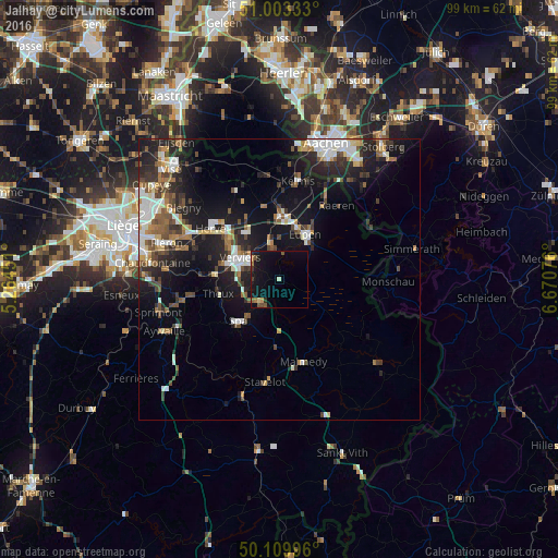
Analysis of Jalhay night lights 2016
Square area 10x10 km:
100  0%
0%
90-99 0.53%
80-89 0.53%
70-79 0.53%
60-69 1.6%
50-59 2.01%
40-49 1.2%
30-39 1.2%
20-29 0.94%
10-19 13.5%
0-9 77.94%
0%90-99
0.53%80-89
0.53%70-79
0.53%60-69
1.6%50-59
2.01%40-49
1.2%30-39
1.2%20-29
0.94%10-19
13.5%0-9
77.94%Square area 50x50 km:
100 2.03%
90-99 2.4%
80-89 0.99%
70-79 0.86%
60-69 1.73%
50-59 1.9%
40-49 1.99%
30-39 2.03%
20-29 3.98%
10-19 10.34%
0-9 71.75%
2.03%90-99
2.4%80-89
0.99%70-79
0.86%60-69
1.73%50-59
1.9%40-49
1.99%30-39
2.03%20-29
3.98%10-19
10.34%0-9
71.75%Clear (daylight) street map image can be seen on geolist.org.
Map coordinates:
51° 0' 12" North, 5° 15' 52.2" East
50° 33' 31.5" North, 5° 58' 3.5" East
50° 6' 35.9" North, 6° 40' 14.7" East
Some cities around Jalhay sort by population:
• Verviers
8.2 km =5.1 mi,  294°
294°
• Eupen
9.1 km =5.7 mi,  32°
32°
• Dison
9.9 km =6.2 mi,  305°
305°
• Theux
11.3 km =7 mi,  255°
255°
• Spa
11 km =6.8 mi,  220°
220°
• Pepinster
11.6 km =7.2 mi,  278°
278°
• Welkenraedt
11.3 km =7 mi,  0°
0°
• Limbourg
6.2 km =3.9 mi,  342°
342°
2794989 (p: 7,688)
Sources (retrieved 2019-11-25):
» Earth at Night: Flat Maps 2012, 2016