La Calamine night lights from space
Night Light of La Calamine (Wallonia) from space (Belgium) Src. Average luminocity for 10x10km area is 15.9265% and for 50x50km: 22.4102%.
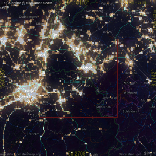
Analysis of La Calamine night lights 2016
Square area 10x10 km:
 0.67%
0.67%90-99
1.2%80-89
0.8%70-79
0.53%60-69
1.87%50-59
1.6%40-49
2.54%30-39
2.41%20-29
10.29%10-19
30.08%0-9
47.99%Square area 50x50 km:
2.93%90-99
4.14%80-89
2.06%70-79
2.02%60-69
2.86%50-59
3.62%40-49
3.29%30-39
4.34%20-29
8.68%10-19
17.11%0-9
48.94%Clear (daylight) street map image can be seen on geolist.org.
Map coordinates:
51° 9' 40.1" North, 5° 18' 28.6" East
50° 43' 5.1" North, 6° 0' 39.9" East
50° 16' 14.9" North, 6° 42' 51.1" East
Some cities around La Calamine sort by population:
• Aachen, DE
8.3 km =5.2 mi,  38°
38°
• Würselen, DE
14.1 km =8.8 mi, 38°
• Eupen
10.2 km =6.3 mi,  169°
169°
• Raeren
9.3 km =5.8 mi,  127°
127°
• Plombières
4.2 km =2.6 mi,  299°
299°
• Welkenraedt
7 km =4.3 mi,  204°
204°
• Vaals, NL
5.9 km =3.7 mi,  4°
4°
• Limbourg
12.8 km =8 mi, 202°
2793722 (p: 10,232)
Sources (retrieved 2019-11-25):
» Earth at Night: Flat Maps 2012, 2016