Dison night lights from space
Night Light of Dison (Wallonia) from space (Belgium) Src. Average luminocity for 10x10km area is 43.0455% and for 50x50km: 20.5927%.
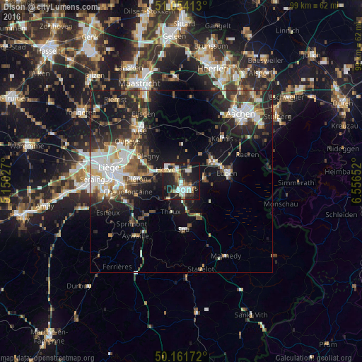
Analysis of Dison night lights 2016
Square area 10x10 km:
100  8.16%
8.16%
90-99 10.29%
80-89 4.41%
70-79 2.41%
60-69 6.15%
50-59 3.21%
40-49 5.21%
30-39 7.22%
20-29 16.58%
10-19 34.63%
0-9 1.74%
8.16%90-99
10.29%80-89
4.41%70-79
2.41%60-69
6.15%50-59
3.21%40-49
5.21%30-39
7.22%20-29
16.58%10-19
34.63%0-9
1.74%Square area 50x50 km:
100 3.67%
90-99 4.41%
80-89 1.74%
70-79 1.46%
60-69 2.35%
50-59 2.82%
40-49 2.9%
30-39 3.41%
20-29 6.85%
10-19 14.56%
0-9 55.84%
3.67%90-99
4.41%80-89
1.74%70-79
1.46%60-69
2.35%50-59
2.82%40-49
2.9%30-39
3.41%20-29
6.85%10-19
14.56%0-9
55.84%Clear (daylight) street map image can be seen on geolist.org.
Map coordinates:
51° 3' 14.9" North, 5° 9' 1" East
50° 36' 36.1" North, 5° 51' 12.2" East
50° 9' 42.2" North, 6° 33' 23.5" East
Some cities around Dison sort by population:
• Verviers
2.4 km =1.5 mi,  164°
164°
• Herve
5.4 km =3.4 mi,  309°
309°
• Soumagne
7.5 km =4.7 mi,  273°
273°
• Theux
9 km =5.6 mi,  198°
198°
• Pepinster
5.3 km =3.3 mi,  220°
220°
• Welkenraedt
10 km =6.2 mi,  55°
55°
• Jalhay
9.9 km =6.2 mi,  125°
125°
• Limbourg
6.2 km =3.9 mi,  87°
87°
2799347 (p: 13,642)
Sources (retrieved 2019-11-25):
» Earth at Night: Flat Maps 2012, 2016